Bärensteinrunde short


- Suitable for families
- Suitable for kids (all ages)
- Flatly
- Possible accommodation
Interactive elevation profile
Create PDF
Tour-Details
Path number: 41
Starting place: 4160 Aigen-Schlägl
Destination: 4160 Aigen-Schlägl
duration: 1h 0m
length: 3,5 km
Altitude difference (uphill): 98m
Altitude difference (downhill): 95m
Lowest point: 966m
Highest point: 1.058m
difficulty: medium
condition: medium
panoramic view: Great panorama
Paths covering:
Asphalt, Path / trail, Hiking trail
powered by TOURDATA
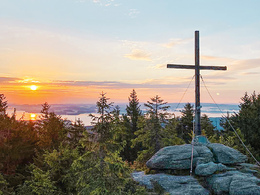
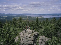
The Bärenstein with its magnificent panoramic view of the South Bohemian Vltava Lake, to the founder's village of Oberplan, to the entire Bohemian Forest area and, with a good distant view, all the way to the Alps.
How to get there: Aigen-Schlägl Nord, first road (at the zebra crossing) left into Höhenstraße. Approx. 5 km uphill through the forest to Grünwald, the plateau at the very end.
Markings: Yellow aluminium signs, shortened variant Bärensteinrunde, also red-white-red colour markings on trees.
0 km Starting point Grünwald car park / (926 m).
Grünwald used to be a pure woodcutters' settlement. The Panyhaus takes its name from the enterprising clerk of Schlägl Abbey Josef Pany, a passionate property and house broker who bought plots of land in several villages in the region around 1825 and had small houses built. For example, he founded the village of Panidorf between Klaffer and Schwarzenberg. He would have liked to have built the Panyhaus himself, but he never got round to it. As both land and plans were available, his sister had this house built after his death in 1851, the first house in Grünwald.
From the car park, turn right into the asphalt road. After approx. 200 metres, leave the road and follow the dirt track to the right. Now continue slightly uphill on the forest path to the
1.6 km Bärenstein (1077 m), with a magnificent view of the Vltava reservoir. The Bohemian Massif was formed 300 million years ago. Rainwater seeping into the earth washed out underground fissures and caves, the decomposition of the granite blocks began and the round wool sack shapes were formed. Continue along the forest path moderately downhill to
3.0 km Grünwald to the starting point.
Request our hiking map for EUR 3.00 .
With the free outdooractive app, you can hike the trail using navigation.
Starting point: Car park in Grünwald (cross-country skiing hut).
Destination: Starting point.
further information:
- Flatly
- Possible accommodation
- Board possible
- Suitable for schools
- Suitable for kids (all ages)
- Suitable for teenagers
- Suitable for seniors
- Suitable for single travelers
- Suitable for friends
- Suitable for couples
- Suitable for children
- Spring
- Summer
- Autumn
Please get in touch for more information.
Dreisesselbergstraße 18
4160 Aigen-Schlägl
Phone +43 5 7890 - 100
Fax machine +43 5 7890 - 115
E-Mail info@boehmerwald.at
Web www.boehmerwald.at
https://www.boehmerwald.at
You can also visit us on
Visit us on Facebook Visit us on Instagram Visit our videochannel on YouTube")
")
Interactive elevation profile
Create PDF
Tour-Details
Path number: 41
Starting place: 4160 Aigen-Schlägl
Destination: 4160 Aigen-Schlägl
duration: 1h 0m
length: 3,5 km
Altitude difference (uphill): 98m
Altitude difference (downhill): 95m
Lowest point: 966m
Highest point: 1.058m
difficulty: medium
condition: medium
panoramic view: Great panorama
Paths covering:
Asphalt, Path / trail, Hiking trail
powered by TOURDATA
