Plöckensteinerseeweg


- Flatly
- Possible accommodation
Interactive elevation profile
Create PDF
Tour-Details
Path number: 21
Starting place: 4163 Klaffer am Hochficht
Destination: 4163 Klaffer am Hochficht
duration: 6h 0m
length: 19,3 km
Altitude difference (uphill): 675m
Altitude difference (downhill): 678m
Lowest point: 893m
Highest point: 1.368m
difficulty: difficult
condition: difficult
panoramic view: Great panorama
Paths covering:
Path / trail, Gravel, unfixed, Hiking trail
powered by TOURDATA
Demanding tour through the Bohemian Forest to "god's eye" as Adalbert Stifter called the Plöckenstein lake.
Other highlights include the Adalbert Stifter monument and the Plöckenstein, the highest peak in Šumava. A hike through the Sumava nature reserve.
0 km You start the hike at the Ereignishaus Holzschlag. Following the yellow signpost no. 21, hike slightly uphill on the forest road, crossing the ski slope of the Rehberglift, into the high forest of the Bohemian Forest and arrive at the ...
3.3 km border crossing 1/10. Continue the hike on the following tarmac path. A white-blue-white tree marking accompanies you here. After ...
5.4 km downhill, you will reach Hirschröhren (Říjiště). Turn left at the rest hut. The tree markings are now white-green-white. After a short ascent, leave the road and turn left into the forest. This is followed by a beautiful uphill, stony hiking trail. From here on, surefootedness and good footwear are required. You are now in a nature reserve. Do not leave the path! At the Pod Kamenným Morem site (1050 m), take the right branch of the path. After approx. 1 km, a path lined with mountain pines and blueberries leads to ...
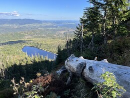
8.3 km Plöckensteinersee, which Adalbert Stifter called "The Eye of God". A legend tells that a magnificent castle with greedy lords once stood on the heights of the Plöckenstein. One day, a judgement fell upon them. Suddenly the sky clouded over, lightning flashed and heavy rain poured down. A ray of lightning struck the Plöckenstein and split the mountain in two. A chasm opened up and the mountain massif sank along with the castle. When the storm was over, the people saw that the castle had been destroyed and that where the lightning had split the mountain, an abruptly falling rock face and a dark lake had formed. Follow the tree markings white-yellow-white. A steep, rooty, stony but beautiful forest path follows through the nature reserve up to the ...
9.9 km Adalbert Stifter monument. The effort of the approximately ¾-hour steep climb is rewarded with a magnificent view of the lake and into the countryside. This obelisk was erected in 1876/77 at the request of the Friedberg school headmaster and writer Jordan Kajetan Markus in memory of the famous Bohemian Forest poet Adalbert Stifter. After 15-20 minutes you reach the ...
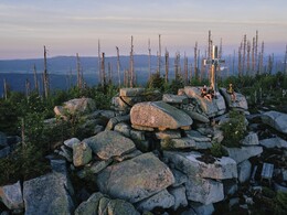
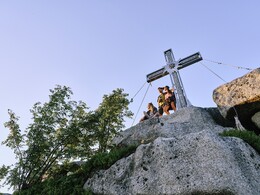
11.0 km Plöckenstein, with its 1379 m the highest mountain in the Mühlviertel. Here you are again accompanied by trail marker no. 21 to the starting point. You walk left along the border line until the terrain drops steeply downhill. Here you continue to the right, past the "burnt stones" (as the sea of rocks is called).
Always downhill you reach the forest road and continue downhill along the forest path to the "Zwieselberg" shelter hut and the old customs hut. Here you meet the Nordwaldkammweg. Turn left onto the forest road and stay on it
13.6 km Here you can take the 300m long detour to the Lisei picture, where you can read the sad story of the forester's daughter who was madly in love with a smuggler. Back again, walk along the forest road to the place where the Sterzvilla once stood. This is a simple hut where the woodcutters cooked their food. Sterz is a dish made from potatoes, flour and lard
16.0 km From the border crossing 1/10, you walk back along the familiar forest path to the ...
19.3 km Ereignishaus Holzschlag.
Request our hiking map for EUR 3.00!
With the free app outdooractive you can hike the trail by navigation.
Other highlights include the Adalbert Stifter monument and the Plöckenstein, the highest peak in Šumava. A hike through the Sumava nature reserve.
0 km You start the hike at the Ereignishaus Holzschlag. Following the yellow signpost no. 21, hike slightly uphill on the forest road, crossing the ski slope of the Rehberglift, into the high forest of the Bohemian Forest and arrive at the ...
3.3 km border crossing 1/10. Continue the hike on the following tarmac path. A white-blue-white tree marking accompanies you here. After ...
5.4 km downhill, you will reach Hirschröhren (Říjiště). Turn left at the rest hut. The tree markings are now white-green-white. After a short ascent, leave the road and turn left into the forest. This is followed by a beautiful uphill, stony hiking trail. From here on, surefootedness and good footwear are required. You are now in a nature reserve. Do not leave the path! At the Pod Kamenným Morem site (1050 m), take the right branch of the path. After approx. 1 km, a path lined with mountain pines and blueberries leads to ...
8.3 km Plöckensteinersee, which Adalbert Stifter called "The Eye of God". A legend tells that a magnificent castle with greedy lords once stood on the heights of the Plöckenstein. One day, a judgement fell upon them. Suddenly the sky clouded over, lightning flashed and heavy rain poured down. A ray of lightning struck the Plöckenstein and split the mountain in two. A chasm opened up and the mountain massif sank along with the castle. When the storm was over, the people saw that the castle had been destroyed and that where the lightning had split the mountain, an abruptly falling rock face and a dark lake had formed. Follow the tree markings white-yellow-white. A steep, rooty, stony but beautiful forest path follows through the nature reserve up to the ...
9.9 km Adalbert Stifter monument. The effort of the approximately ¾-hour steep climb is rewarded with a magnificent view of the lake and into the countryside. This obelisk was erected in 1876/77 at the request of the Friedberg school headmaster and writer Jordan Kajetan Markus in memory of the famous Bohemian Forest poet Adalbert Stifter. After 15-20 minutes you reach the ...
11.0 km Plöckenstein, with its 1379 m the highest mountain in the Mühlviertel. Here you are again accompanied by trail marker no. 21 to the starting point. You walk left along the border line until the terrain drops steeply downhill. Here you continue to the right, past the "burnt stones" (as the sea of rocks is called).
Always downhill you reach the forest road and continue downhill along the forest path to the "Zwieselberg" shelter hut and the old customs hut. Here you meet the Nordwaldkammweg. Turn left onto the forest road and stay on it
13.6 km Here you can take the 300m long detour to the Lisei picture, where you can read the sad story of the forester's daughter who was madly in love with a smuggler. Back again, walk along the forest road to the place where the Sterzvilla once stood. This is a simple hut where the woodcutters cooked their food. Sterz is a dish made from potatoes, flour and lard
16.0 km From the border crossing 1/10, you walk back along the familiar forest path to the ...
19.3 km Ereignishaus Holzschlag.
Request our hiking map for EUR 3.00!
With the free app outdooractive you can hike the trail by navigation.
Starting point: Ereignishaus Holzschlag.
Destination: Ereignishaus Holzschlag.
further information:
- Flatly
- Possible accommodation
- Board possible
Most economical season
- Spring
- Summer
- Autumn
Please get in touch for more information.
Dorfplatz 1
4163 Klaffer am Hochficht
Phone +43 5 7890 - 100
Fax machine +43 5 7890 - 115
E-Mail info@boehmerwald.at
Web www.boehmerwald.at/
https://www.boehmerwald.at/
You can also visit us on
Visit us on Facebook Visit us on Instagram Visit our videochannel on YouTube")
")
")
")
")
")
Interactive elevation profile
Create PDF
Tour-Details
Path number: 21
Starting place: 4163 Klaffer am Hochficht
Destination: 4163 Klaffer am Hochficht
duration: 6h 0m
length: 19,3 km
Altitude difference (uphill): 675m
Altitude difference (downhill): 678m
Lowest point: 893m
Highest point: 1.368m
difficulty: difficult
condition: difficult
panoramic view: Great panorama
Paths covering:
Path / trail, Gravel, unfixed, Hiking trail
powered by TOURDATA
