Feuchtenbachweg


- pets allowed
- All weather
- Flatly
Interactive elevation profile
Create PDF
Tour-Details
Path number: 30
Starting place: 4120 Neufelden
Destination: 4120 Neufelden
duration: 1h 34m
length: 5,3 km
Altitude difference (uphill): 138m
Altitude difference (downhill): 144m
Lowest point: 469m
Highest point: 604m
difficulty: very easy
condition: very easy
panoramic view: Some Views
powered by TOURDATA
Leisurely hiking route for the whole family with short climbs. ROUTENVERLAUF: First in the direction of the reservoir, then through the large and quiet Feuchtenbach forest to the Waldandacht. Then a medium gradient to the Altenfelden sports ground. Through the outskirts of Altenfelden, you return to Neufelden via the Schürz composting plant (Höferhof). Forest/forest edge: 20 %, tarmac: 80 %
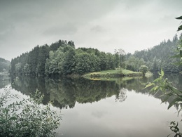
VIEW: Before the Feuchtenbachwald forest, beautiful view of the Neufelden reservoir. Between Altenfelden and the Schürz composting plant (Höferhof), good distant views of the Limestone Alps
With the free outdooractive app, you can hike the trail using navigation.
VIEW: Before the Feuchtenbachwald forest, beautiful view of the Neufelden reservoir. Between Altenfelden and the Schürz composting plant (Höferhof), good distant views of the Limestone Alps
With the free outdooractive app, you can hike the trail using navigation.
- All weather
- Pets allowed
- Spring
- Summer
- Autumn
Please get in touch for more information.
Markt 22
4120 Neufelden
Phone +43 5 7890 - 100
Fax machine +43 5 7890 - 115
E-Mail info@boehmerwald.at
Web www.boehmerwald.at
https://www.boehmerwald.at
You can also visit us on
Visit us on Facebook Visit us on Instagram Visit our videochannel on YouTubeInteractive elevation profile
Create PDF
Tour-Details
Path number: 30
Starting place: 4120 Neufelden
Destination: 4120 Neufelden
duration: 1h 34m
length: 5,3 km
Altitude difference (uphill): 138m
Altitude difference (downhill): 144m
Lowest point: 469m
Highest point: 604m
difficulty: very easy
condition: very easy
panoramic view: Some Views
powered by TOURDATA
