Lauf- und Wanderstrecke Euroline-Runde


- Flatly
Interactive elevation profile
Create PDF
Tour-Details
Starting place: 4150 Rohrbach-Berg
Destination: 4150 Oepping
duration: 2h 58m
length: 10,0 km
Altitude difference (uphill): 264m
Altitude difference (downhill): 250m
Lowest point: 543m
Highest point: 683m
difficulty: medium
condition: medium
panoramic view: Individual Views
Paths covering:
Asphalt
powered by TOURDATA
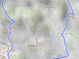
Beautiful circular route of the district capital Rohrbach-Berg. Length: 9.80 km
VILLA sinnenreich > Perwolfing > Obermärzing > Märzing > Gintersberg > VILLA sinnenreich
With the free outdooractive app, you can walk the trail using navigation.
VILLA sinnenreich > Perwolfing > Obermärzing > Märzing > Gintersberg > VILLA sinnenreich
With the free outdooractive app, you can walk the trail using navigation.

Most economical season
- Spring
- Summer
- Autumn
Please get in touch for more information.
Stadtplatz 1
4150 Rohrbach-Berg
Phone +43 7289 6255
E-Mail stadt@rohrbach-berg.ooe.gv.at
You can also visit us on
Visit us on Facebook Visit us on Instagram Visit our videochannel on YouTubeInteractive elevation profile
Create PDF
Tour-Details
Starting place: 4150 Rohrbach-Berg
Destination: 4150 Oepping
duration: 2h 58m
length: 10,0 km
Altitude difference (uphill): 264m
Altitude difference (downhill): 250m
Lowest point: 543m
Highest point: 683m
difficulty: medium
condition: medium
panoramic view: Individual Views
Paths covering:
Asphalt
powered by TOURDATA
