Walkingstrecke Günterreithersteig


- Flatly
Interactive elevation profile
Create PDF
Tour-Details
Starting place: 4170 St. Oswald bei Haslach
Destination: 4170 St. Oswald bei Haslach
duration: 2h 12m
length: 6,7 km
Altitude difference (uphill): 266m
Altitude difference (downhill): 275m
Lowest point: 582m
Highest point: 755m
difficulty: medium
condition: medium
panoramic view: Individual Views
Paths covering:
Asphalt, Gravel, Hiking trail, Other
powered by TOURDATA
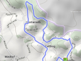
Walking route of the municipality of St. Oswald.
Starting point: St. Oswald village square
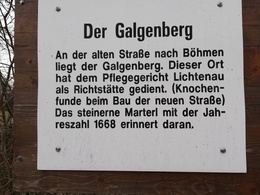
We head north, past the old fire station to the Galgenberg. At the Galgenberg, follow the Nordwaldkammweg markings to the left. Walk along the edge of the forest down to Sattling. After a short tarmac section, a dirt track on the right leads up to the forest. In the forest, the trail climbs gently in a westerly direction. Keep left at the prominent crossroads in the forest. The route now heads downhill towards Günterreith. Shortly before Günterreith, a marvellous view far beyond the Mühltal makes your heart beat faster. The path leads through Günterreith; keep left in the middle of the village; cross the main road and follow the tarmac road downhill. In front of us we see Sattling and behind it St. Oswald. In Sattling, we cross the road and follow the field path towards St. Oswald.
150 metres after Sattling, we cross a small stream, then turn right onto the field path towards Laimbach. In Laimbach we come to a tarmac road again. Keep left and after 150 metres turn left onto the field path. After 300 metres, turn right at the sports field and follow the road. After a further 200 metres, we are back at the village square.
The route is approx. 6.9 km long
You can use the free outdooractive app to navigate the route.
Starting point: St. Oswald village square
We head north, past the old fire station to the Galgenberg. At the Galgenberg, follow the Nordwaldkammweg markings to the left. Walk along the edge of the forest down to Sattling. After a short tarmac section, a dirt track on the right leads up to the forest. In the forest, the trail climbs gently in a westerly direction. Keep left at the prominent crossroads in the forest. The route now heads downhill towards Günterreith. Shortly before Günterreith, a marvellous view far beyond the Mühltal makes your heart beat faster. The path leads through Günterreith; keep left in the middle of the village; cross the main road and follow the tarmac road downhill. In front of us we see Sattling and behind it St. Oswald. In Sattling, we cross the road and follow the field path towards St. Oswald.
150 metres after Sattling, we cross a small stream, then turn right onto the field path towards Laimbach. In Laimbach we come to a tarmac road again. Keep left and after 150 metres turn left onto the field path. After 300 metres, turn right at the sports field and follow the road. After a further 200 metres, we are back at the village square.
The route is approx. 6.9 km long
You can use the free outdooractive app to navigate the route.
Most economical season
- Spring
- Summer
- Autumn
Please get in touch for more information.
Gemeindeamt St. Oswald
4170 St. Oswald bei Haslach
Phone +43 7289 71555
E-Mail gemeinde@st-oswald-haslach.ooe.gv.at
You can also visit us on
Visit us on Facebook Visit us on Instagram Visit our videochannel on YouTubeInteractive elevation profile
Create PDF
Tour-Details
Starting place: 4170 St. Oswald bei Haslach
Destination: 4170 St. Oswald bei Haslach
duration: 2h 12m
length: 6,7 km
Altitude difference (uphill): 266m
Altitude difference (downhill): 275m
Lowest point: 582m
Highest point: 755m
difficulty: medium
condition: medium
panoramic view: Individual Views
Paths covering:
Asphalt, Gravel, Hiking trail, Other
powered by TOURDATA
