Ski tour to the Plöckenstein


Interactive elevation profile
Create PDF
Tour-Details
Path number: Orangene Schilder
Starting place: 4164 Schwarzenberg am Böhmerwald
Destination: 4164 Schwarzenberg am Böhmerwald
duration: 3h 0m
length: 10,0 km
Altitude difference (uphill): 426m
Altitude difference (downhill): 456m
Lowest point: 953m
Highest point: 1.375m
difficulty: medium
condition: medium
panoramic view: Great panorama
Paths covering:
snow
powered by TOURDATA
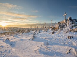
This ski tour is marked with orange signs. You start the 10 km tour in Oberschwarzenberg at car park P1 or P2. Follow the road steadily uphill until you reach the entrance just before the border. Now the trail goes mostly steeply uphill for about 5 km. Keep to the signs. Pass the Devil's Bowls until you reach the ridge. From here you have a fantastic view over the Mühlviertel and the Bavarian Forest. The descent brings you back to the starting point along the same route.
Starting point: Oberschwarzenberg at the last car park.
Destination: Starting point.
Details - Ski
- Descent: difficulty: medium, 426 Metres of altitude
Most economical season
- Deep winter
Please get in touch for more information.
Hauptstraße 4
4164 Schwarzenberg am Böhmerwald
Phone +43 5 7890 - 100
Fax machine +43 5 7890 - 115
E-Mail info@boehmerwald.at
Web www.boehmerwald.at
https://www.boehmerwald.at
You can also visit us on
Visit us on Facebook Visit us on Instagram Visit our videochannel on YouTubeInteractive elevation profile
Create PDF
Tour-Details
Path number: Orangene Schilder
Starting place: 4164 Schwarzenberg am Böhmerwald
Destination: 4164 Schwarzenberg am Böhmerwald
duration: 3h 0m
length: 10,0 km
Altitude difference (uphill): 426m
Altitude difference (downhill): 456m
Lowest point: 953m
Highest point: 1.375m
difficulty: medium
condition: medium
panoramic view: Great panorama
Paths covering:
snow
powered by TOURDATA
