On the way to decleration: Haslach - Helfenberg, 20 km


- Possible accommodation
Interactive elevation profile
Create PDF
Tour-Details
Path number: Gelbe Schilder mit Entschleunigungs-Symbol
Starting place: 4170 Haslach an der Mühl
Destination: 4184 Helfenberg
duration: 5h 31m
length: 19,8 km
Altitude difference (uphill): 600m
Altitude difference (downhill): 550m
Lowest point: 530m
Highest point: 880m
difficulty: medium
condition: medium
panoramic view: Great panorama
Paths covering:
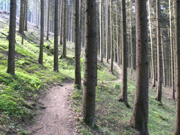
Asphalt, Gravel, Hiking trail
powered by TOURDATA
Haslach – Rohrbach-Berg
20 km, walking distance approx. 5.5 h, approx. 550 m difference in altitude
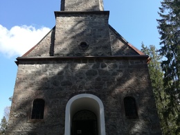
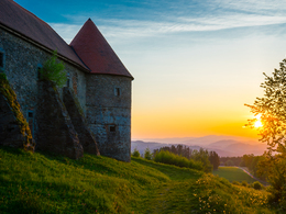
The stage to Helfenberg follows part of the Nordwaldkammweg trail. The places of power along the way are the Maria Rast forest chapel and Piberstein Castle.
You can find the route digitally in the App Komoot.
We are also happy to provide you with a detailed description of the stage on request. This is also available for download under Multimedia/Documents.
With the free outdooractive app, you can hike the route using navigation.
20 km, walking distance approx. 5.5 h, approx. 550 m difference in altitude
The stage to Helfenberg follows part of the Nordwaldkammweg trail. The places of power along the way are the Maria Rast forest chapel and Piberstein Castle.
You can find the route digitally in the App Komoot.
We are also happy to provide you with a detailed description of the stage on request. This is also available for download under Multimedia/Documents.
With the free outdooractive app, you can hike the route using navigation.
further information:
- Possible accommodation
- Experience of nature
- Board possible
Details - hiking
- themed path
- Suitable for single travelers
- Suitable for couples
- Spring
- Summer
- Autumn
Please get in touch for more information.
Stahlmühle 4
4170 Haslach an der Mühl
Phone +43 5 7890 - 100
Fax machine +43 5 7890 - 115
E-Mail info@boehmerwald.at
Web www.wegderentschleunigung.at
https://www.wegderentschleunigung.at
You can also visit us on
Visit us on Facebook Visit us on Instagram Visit our videochannel on YouTubeInteractive elevation profile
Create PDF
Tour-Details
Path number: Gelbe Schilder mit Entschleunigungs-Symbol
Starting place: 4170 Haslach an der Mühl
Destination: 4184 Helfenberg
duration: 5h 31m
length: 19,8 km
Altitude difference (uphill): 600m
Altitude difference (downhill): 550m
Lowest point: 530m
Highest point: 880m
difficulty: medium
condition: medium
panoramic view: Great panorama
Paths covering:
Asphalt, Gravel, Hiking trail
powered by TOURDATA
