Höhenweg


- All weather
- Flatly
- Possible accommodation
Interactive elevation profile
Create PDF
Tour-Details
Path number: J3
Starting place: 4172 St. Johann am Wimberg
Destination: 4172 St. Johann am Wimberg
duration: 1h 12m
length: 4,2 km
Altitude difference (uphill): 84m
Altitude difference (downhill): 84m
Lowest point: 714m
Highest point: 807m
difficulty: easy
condition: easy
panoramic view: Great panorama
Paths covering:
Asphalt, unfixed, Hiking trail
powered by TOURDATA
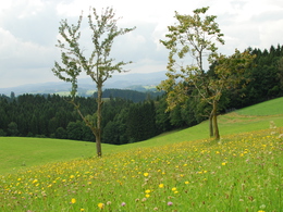
Höhenweg,
as the name suggests, you move above the rooftops of St. Johann.
The start is in the centre of the village by the hiking board. Now it's uphill, initially on the local road towards Penning, but then it's off into the countryside. Through a small wooded area, you reach the chapel via the Kalvarienberg. The circular route then takes you upwards, alternating between local roads and forest paths. Outside the forest, you can enjoy a marvellous view that stretches as far as the Alps. The trail then descends again and you come into the village from the other side.
A beautiful short hiking trail that is also suitable for children.
With the free outdooractive app, you can hike the trail using navigation.
- All weather
- Suitable for groups
- Suitable for schools
- Suitable for single travelers
- Suitable for friends
- Spring
- Summer
- Autumn
- Early winter
- Deep winter
Please get in touch for more information.
St. Johann 10
4172 St. Johann am Wimberg
Phone +43 7217 7155
E-Mail gemeinde@stjohannamwimberg.at
Web www.stjohannamwimberg.at
https://www.stjohannamwimberg.at
You can also visit us on
Visit us on Facebook Visit us on Instagram Visit our videochannel on YouTubeInteractive elevation profile
Create PDF
Tour-Details
Path number: J3
Starting place: 4172 St. Johann am Wimberg
Destination: 4172 St. Johann am Wimberg
duration: 1h 12m
length: 4,2 km
Altitude difference (uphill): 84m
Altitude difference (downhill): 84m
Lowest point: 714m
Highest point: 807m
difficulty: easy
condition: easy
panoramic view: Great panorama
Paths covering:
Asphalt, unfixed, Hiking trail
powered by TOURDATA
