On the way to deceleration: discover special features in 4 days on 78 km


- Multi-day tour
- Flatly
- Possible accommodation
Interactive elevation profile
Create PDF
Tour-Details
Path number: Gelbe Schilder mit Entschleunigungs-Symbol
Starting place: 4160 Aigen-Schlägl
Destination: 4160 Aigen-Schlägl
duration: 22h 9m
length: 77,3 km
Altitude difference (uphill): 1.902m
Altitude difference (downhill): 1.900m
Lowest point: 490m
Highest point: 880m
difficulty: medium
condition: medium
panoramic view: Great panorama
Paths covering:
Asphalt, Hiking trail
powered by TOURDATA
Discover special features in 4 days on 78 km
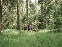
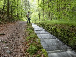
Over 4 days, you will hike through the south-eastern part of the Bohemian Forest and enjoy the hilly landscape of the Mühlviertel at its most beautiful. Experience the different river valleys - you hike from the Große Mühl to the Steinerne to the Kleine Mühl.
Time enough to leave everyday life behind and recharge your batteries.
Time enough to enjoy beautiful places and mystical places of power.
Time enough to simply "unwind" on the beautiful benches along the way.
On request, we will also be happy to provide you with a detailed description of the individual stages. This is also available for download under Multimedia/Documents.With the free outdooractive app, you can hike the route using navigation.
Over 4 days, you will hike through the south-eastern part of the Bohemian Forest and enjoy the hilly landscape of the Mühlviertel at its most beautiful. Experience the different river valleys - you hike from the Große Mühl to the Steinerne to the Kleine Mühl.
Time enough to leave everyday life behind and recharge your batteries.
Time enough to enjoy beautiful places and mystical places of power.
Time enough to simply "unwind" on the beautiful benches along the way.
- Stage 1: Aigen-Schlägl - Haslach, 19 km
- 2. Stage: Haslach - Helfenberg, 20 km
- Stage 3: Helfenberg - Rohrbach-Berg, 20 km
- Stage 4: Rohrbach-Berg - Aigen-Schlägl, 19 km
On request, we will also be happy to provide you with a detailed description of the individual stages. This is also available for download under Multimedia/Documents.With the free outdooractive app, you can hike the route using navigation.
Starting point: Schlägl Abbey in Aigen-Schlägl.
Destination: Schlägl Abbey in Aigen-Schlägl.
further information:
- Multi-day tour
- Flatly
- Possible accommodation
- Experience of nature
- Board possible
Details - hiking
- themed path
1 May to 31 October.
Accessibility / arrival
Directions Aigen-Schlägl
Westautobahn - Linz - B 127
Via Munich - Landshut - A92 - Deggendorf - Passau A3 - Exit
North via Wegscheid
Via Nuremberg - Regensburg A3 - Passau - exit north via Wegscheid
- Suitable for seniors
- Suitable for single travelers
- Suitable for couples
- Spring
- Summer
- Autumn
Please get in touch for more information.
Dreisesselbergstraße 18
4160 Aigen-Schlägl
Phone +43 5 7890 - 100
Fax machine +43 5 7890 - 115
E-Mail info@boehmerwald.at
Web www.wegderentschleunigung.at
https://www.wegderentschleunigung.at
You can also visit us on
Visit us on Facebook Visit us on Instagram Visit our videochannel on YouTube")
Interactive elevation profile
Create PDF
Tour-Details
Path number: Gelbe Schilder mit Entschleunigungs-Symbol
Starting place: 4160 Aigen-Schlägl
Destination: 4160 Aigen-Schlägl
duration: 22h 9m
length: 77,3 km
Altitude difference (uphill): 1.902m
Altitude difference (downhill): 1.900m
Lowest point: 490m
Highest point: 880m
difficulty: medium
condition: medium
panoramic view: Great panorama
Paths covering:
Asphalt, Hiking trail
powered by TOURDATA
