Glashüttenweg


- Flatly
- Possible accommodation
Interactive elevation profile
Create PDF
Tour-Details
Path number: 63
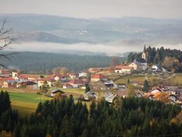
Starting place: 4164 Schwarzenberg am Böhmerwald
Destination: 4164 Schwarzenberg am Böhmerwald
duration: 1h 30m
length: 5,3 km
Altitude difference (uphill): 177m
Altitude difference (downhill): 178m
Lowest point: 783m
Highest point: 951m
difficulty: medium
condition: medium
panoramic view: Some Views
Paths covering:
Asphalt, Hiking trail
powered by TOURDATA
information: Akutmeldung/Information
The name of the path comes from the glassworks era of this region. In 1719, the Schlägl monastery built the Schwarzenberg glassworks, which was in operation for 30 years. 17 people were employed here to produce crystal glass, ruby and other coloured glass. This glass as well as hollow glass, bull's-eye panes and pearls were sold to Bad Ischl, Ottensheim and Passau, Krumau, Vienna and Hungary. Exhibition on glass production in the Kulturhaus Ulrichsberg.
Cross-border hiking trail - travel document required!
0 km The hike starts at Gasthof Dreiländereck in Oberschwarzenberg. Follow the little-used tarmac road on a moderate incline to the end of the road.
1.6 km Immediately at the end of the road, take the path to the left and shortly afterwards cross the Grenzbach stream in the hollow. Continue left, always downhill through the forest, followed by the babbling Grenzbach stream, and after about 15 minutes you will emerge from the forest again. The tarmac road begins, leading you downhill through the scattered settlement of Lackenhäuser. Continue left at the Lackenhäuser fire station and you have already reached the ...
3.2 km Rosenberger Gut. "My whole soul is attached to this area," wrote Adalbert Stifter to Franz Xaver Rosenberger in 1865. He often stayed here at the Rosenbergergut to chat with the old Rosenberger, to write his work "Witiko", or later when he was recovering from his illnesses. Two memorial rooms have been set up. You continue the hike downhill. You will already see the camping park on your left and pass the House of the Šumava People. Now look out for the junction to the left. Walk past the fence of the camping site and the small holiday homes and you will soon reach the ...
3.6 km entrance to the camping park. Immediately afterwards, turn left and walk behind the former GH Zitherwirt towards the forest. Shortly afterwards you cross the border stream and you are back on Austrian territory. Ascending slightly, on a beautiful field and meadow path, you reach the Zinngießer Hof
4.5 km The farm is named after a pewterer who appears in documents as early as 1720/21. Each of the three Schwarzenberg glassworks also had a pewter foundry attached to it. You will also come across Jagaspitzweg here. Both lead into the forest on the right behind the farm. An ascending forest path now follows. You reach a mountain meadow and immediately afterwards the tarmac road that leads from Schwarzenberg up to Oberschwarzenberg. On the left, it is only a few minutes to the ...
5.3 km Gasthof Dreiländereck.
Request our hiking map for EUR 3.00!
With the free outdooractive app, you can hike the trail using navigation.
Starting point: Dreiländereck Inn, Oberschwarzenberg. Alternative car park P1 in Oberschwarzenberg (chargeable!).
Destination: Dreiländereck Inn, Oberschwarzenberg. Alternative car park P1 in Oberschwarzenberg (chargeable!).
further information:
- Flatly
- Possible accommodation
- Board possible
Most economical season
- Spring
- Summer
- Autumn
Please get in touch for more information.
Hauptstraße 4
4164 Schwarzenberg am Böhmerwald
Phone +43 5 7890 - 100
Fax machine +43 5 7890 - 115
E-Mail info@boehmerwald.at
Web www.boehmerwald.at
https://www.boehmerwald.at
You can also visit us on
Visit us on Facebook Visit us on Instagram Visit our videochannel on YouTube")
")
Interactive elevation profile
Create PDF
Tour-Details
Path number: 63
Starting place: 4164 Schwarzenberg am Böhmerwald
Destination: 4164 Schwarzenberg am Böhmerwald
duration: 1h 30m
length: 5,3 km
Altitude difference (uphill): 177m
Altitude difference (downhill): 178m
Lowest point: 783m
Highest point: 951m
difficulty: medium
condition: medium
panoramic view: Some Views
Paths covering:
Asphalt, Hiking trail
powered by TOURDATA
