Saubergerweg


- Flatly
Interactive elevation profile
Create PDF
Tour-Details
Path number: 59
Starting place: 4150 Rohrbach-Berg
Destination: 4150 Rohrbach-Berg
duration: 1h 30m
length: 5,5 km
Altitude difference (uphill): 106m
Altitude difference (downhill): 100m
Lowest point: 575m
Highest point: 656m
difficulty: easy
condition: easy
panoramic view: Great panorama
Paths covering:
Asphalt, Hiking trail
powered by TOURDATA
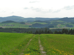
Along the way, beautiful views of the Upper Mühlviertel and the town of Rohrbach-Berg await the hiker again and again.
0 km We start at the car park at the Asphaltstockhalle (opposite Hofer Markt) and walk left towards Lanzerstorf, moderately uphill. (Alternative start at the Hanrieder car park: we follow the road towards the bypass to the Asphaltstockhalle, path extension by approx. 800 m.)
After Lanzerstorf we follow the road for a while until the turn-off at the wayside shrine to Wolkertsberg. We reach the first beautiful vantage point at a bench, which offers a view to the south as far as the Danube valley. The village on the horizon is Pfarrkirchen, if we look to the right we can see Götzendorf Castle
1.3 km Once in Wolkertsberg, we turn right onto the field path after the first house. This is followed by a beautiful flat stretch through fields and meadows. You reach the large ...
2.1 km single farmstead "Sauberger", where you turn sharp left. Now continue along the western side of the Scheiblberg to ...
2.8 km to the village of Autengrub. In the centre of the village, don't overlook the turn-off to the left at the garage. Climbing slightly for a short while, turn left again and follow the beautiful field path that leads downhill into a forest.
On leaving the forest, walk towards the houses. Watch out for the markings that lead us to an old farmhouse. Here we turn right and walk between the farmhouse and a residential building to reach a meadow path. This leads into an asphalt road in the village of Lanzerstorf and brings us back ...
5.5 km to the starting point.
Request our hiking map for EUR 3.00!
With the free outdooractive app, you can hike the trail using navigation.
Starting point: Car park at the asphalt stick hall.
Destination: Car park at the asphalt stick hall.
further information:
- Flatly
- Board possible
Most economical season
- Spring
- Summer
- Autumn
- Early winter
Please get in touch for more information.
Stadtplatz 1
4150 Rohrbach-Berg
Phone +43 5 7890 - 100
Fax machine +43 5 7890 - 115
E-Mail info@boehmerwald.at
Web www.boehmerwald.at
https://www.boehmerwald.at
You can also visit us on
Visit us on Facebook Visit us on Instagram Visit our videochannel on YouTubeInteractive elevation profile
Create PDF
Tour-Details
Path number: 59
Starting place: 4150 Rohrbach-Berg
Destination: 4150 Rohrbach-Berg
duration: 1h 30m
length: 5,5 km
Altitude difference (uphill): 106m
Altitude difference (downhill): 100m
Lowest point: 575m
Highest point: 656m
difficulty: easy
condition: easy
panoramic view: Great panorama
Paths covering:
Asphalt, Hiking trail
powered by TOURDATA
