Panorama trail Rohrbach-Berg


- Flatly
- Possible accommodation
Interactive elevation profile
Create PDF
Tour-Details
Path number: 52
Starting place: 4150 Rohrbach-Berg
Destination: 4150 Rohrbach-Berg
duration: 0h 33m
length: 1,7 km
Altitude difference (uphill): 62m
Altitude difference (downhill): 62m
Lowest point: 635m
Highest point: 681m
difficulty: very easy
condition: very easy
panoramic view: Dreamtour
Paths covering:
Asphalt, Hiking trail
powered by TOURDATA
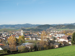
Impressive views over Rohrbach-Berg, the vacation area Bohemian Forest and the Mühlviertel.
0 km You start at the snack station Mosthütte and follow the path uphill towards the Pestsäule. From here, the path runs along the edge of the forest to the right. After a few metres, you reach the ...
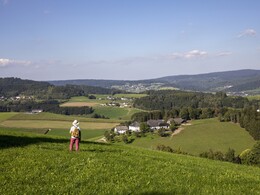
260 m first viewpoint, which offers a wonderful panorama, with Alpine peaks in foehn weather. We follow the path along the forest until we reach the ...
680 m second viewpoint. We overlook the town of Rohrbach-Berg, which has a very special charm when viewed from this spot. Shortly afterwards, we reach the ...
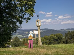
750 m Kriegnerkapelle. We continue to the right - uphill over the exposed, historic stone steps (probably from 1730). Past St Ivo - called Schikanus - the path leads to the road that leads to the Maria Trost church *) (detour of approx. 200 metres). At the Panoramaweg, keep left on the road. After approx. 100 m at the so-called ...
860 m Dreispitz we turn right and follow the edge of the forest on the NW side. We reach the ...
920 m third viewpoint with a wonderful "Bohemian Forest view". The path leads us through the forest to a forest road, on which we turn right and after approx. 100 m reach our starting point, the Mosthütte snack station, which is 1.7 km away.
*) The Maria Trost pilgrimage church was built on the remains of the first mountain castle in fulfilment of a vow. As we walk around the church, we can see the weaving village of Haslach an der Mühl between the trees. A detour along the chapel path takes us to the Maria Hilf Chapel, Maria Schneekapelle and the Holy Sepulchre. If we follow this path, we come out of the forest again at the Pestsäule and downhill we reach our starting point at the Mosthütte snack station.
Request our hiking map for EUR 3.00!
With the free outdooractive app, you can hike the trail by navigation.
- First viewpoint at the Pestsäule (SE side): View to Hansberg - Altenfelden - Scheiblhoferberg - Ennstal Alps - Totes Gebirge - Dachstein.
- Second viewpoint near Kriegnerkapelle (SW side): View to the Totes Gebirge - Dachstein - Watzmann - Scheiblhoferberg - Pfarrkirchen - Rohrbach - Ameisberg - Bavaria.
- Third viewpoint on the way back to the Mosthütte (NW side): View to the Bohemian Forest - Fürlingerberg - Felberau/Dambergschlag.
0 km You start at the snack station Mosthütte and follow the path uphill towards the Pestsäule. From here, the path runs along the edge of the forest to the right. After a few metres, you reach the ...
260 m first viewpoint, which offers a wonderful panorama, with Alpine peaks in foehn weather. We follow the path along the forest until we reach the ...
680 m second viewpoint. We overlook the town of Rohrbach-Berg, which has a very special charm when viewed from this spot. Shortly afterwards, we reach the ...
750 m Kriegnerkapelle. We continue to the right - uphill over the exposed, historic stone steps (probably from 1730). Past St Ivo - called Schikanus - the path leads to the road that leads to the Maria Trost church *) (detour of approx. 200 metres). At the Panoramaweg, keep left on the road. After approx. 100 m at the so-called ...
860 m Dreispitz we turn right and follow the edge of the forest on the NW side. We reach the ...
920 m third viewpoint with a wonderful "Bohemian Forest view". The path leads us through the forest to a forest road, on which we turn right and after approx. 100 m reach our starting point, the Mosthütte snack station, which is 1.7 km away.
*) The Maria Trost pilgrimage church was built on the remains of the first mountain castle in fulfilment of a vow. As we walk around the church, we can see the weaving village of Haslach an der Mühl between the trees. A detour along the chapel path takes us to the Maria Hilf Chapel, Maria Schneekapelle and the Holy Sepulchre. If we follow this path, we come out of the forest again at the Pestsäule and downhill we reach our starting point at the Mosthütte snack station.
Request our hiking map for EUR 3.00!
With the free outdooractive app, you can hike the trail by navigation.
Starting point: Jausenstation Mosthütte, Stifterstraße, Rohrbach-Berg.
Destination: Jausenstation Mosthütte, Stifterstraße, Rohrbach-Berg.
further information:
- Flatly
- Possible accommodation
- Board possible
Most economical season
- Spring
- Summer
- Autumn
Please get in touch for more information.
Stadtplatz 1
4150 Rohrbach-Berg
Phone +43 5 7890 - 100
Fax machine +43 5 7890 - 115
E-Mail info@boehmerwald.at
Web www.boehmerwald.at
https://www.boehmerwald.at
You can also visit us on
Visit us on Facebook Visit us on Instagram Visit our videochannel on YouTube")

Interactive elevation profile
Create PDF
Tour-Details
Path number: 52
Starting place: 4150 Rohrbach-Berg
Destination: 4150 Rohrbach-Berg
duration: 0h 33m
length: 1,7 km
Altitude difference (uphill): 62m
Altitude difference (downhill): 62m
Lowest point: 635m
Highest point: 681m
difficulty: very easy
condition: very easy
panoramic view: Dreamtour
Paths covering:
Asphalt, Hiking trail
powered by TOURDATA
