
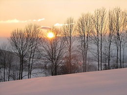
Winterwanderweg: Haslacher Rundumweg


- culinary interesting
- culturally interesting
- Flatly
- Possible accommodation
Interactive elevation profile
Create PDF
Tour-Details
Path number: 75
Starting place: 4170 Haslach an der Mühl
Destination: 4170 Haslach an der Mühl
duration: 1h 0m
length: 4,5 km
Altitude difference (uphill): 30m
Altitude difference (downhill): 33m
Lowest point: 497m
Highest point: 541m
difficulty: easy
condition: easy
panoramic view: Some Views
Paths covering:
snow
powered by TOURDATA
On this hike you can a look at Haslach from every angle.
With the free outdooractive app, you can hike the route using navigation.
further information:
- culinary interesting
- Flatly
- Possible accommodation
- Board possible
Details - hiking
- cleared winter hiking path
Parking
- Parking space: 50
Most economical season
- Early winter
- Deep winter
Please get in touch for more information.
Stahlmühle 4
4170 Haslach an der Mühl
Phone +43 5 07263 - 200
E-Mail boehmerwald@muehlviertel.at
Web www.muehlviertel.at/
https://www.muehlviertel.at/
You can also visit us on
Visit us on Facebook Visit us on Instagram Visit our videochannel on YouTube")
")
")

Interactive elevation profile
Create PDF
Tour-Details
Path number: 75
Starting place: 4170 Haslach an der Mühl
Destination: 4170 Haslach an der Mühl
duration: 1h 0m
length: 4,5 km
Altitude difference (uphill): 30m
Altitude difference (downhill): 33m
Lowest point: 497m
Highest point: 541m
difficulty: easy
condition: easy
panoramic view: Some Views
Paths covering:
snow
powered by TOURDATA
