Torfaurunde


- Suitable for pushchairs
- Flatly
- Possible accommodation
Interactive elevation profile
Create PDF
Tour-Details
Starting place: 4161 Ulrichsberg
Destination: 4161 Ulrichsberg
duration: 4h 0m
length: 11,0 km
Altitude difference (uphill): 209m
Altitude difference (downhill): 209m
Lowest point: 564m
Highest point: 738m
difficulty: easy
condition: easy
panoramic view: Some Views
Paths covering:
Asphalt, Hiking trail
powered by TOURDATA
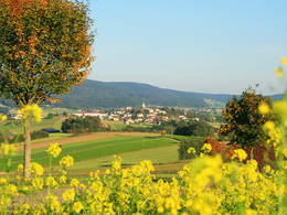
Beautiful hike with a great view of the wonderful Bohemian Forest landscape.
Opposite the waste collection centre, at the Red Cross sign after the building yard, you will come across the Böhmerwaldblickweg trail no. 2 signposts, which will take you to the Torfaurunde junction in Seitelschlag. Cross the Große Mühl and immediately turn right towards Berdetschlag, passing the Resch construction company. After around 700 metres, leave the tarmac road and turn right onto the field path and reach the ...
2 km Schwarzholzkapelle, wonderful views. You will soon come to a fork in the path, where
you continue to the right. Shortly afterwards, a detour to the Berdetschläger mill (180 m) is possible. Continue along the beautiful country lane to the ...
4.3 km Torfaurunde turn-off. This loop is 2.5 km long and you will come across the information boards of the landscape adventure trail. The Haslach Nature Conservation Youth created the adventure trail together with the agricultural district authority. Topics such as the landscape history of the village of Seitelschlag, crop rotation, fauna and flora habitats, peat extraction and monoculture can be read about on information boards.
The hike takes you back to Ulrichsberg along the same route.
The village of Seitelschlag can also be chosen as the starting point: At the village square by the large chestnut tree, turn right onto the field path and shortly afterwards you will reach the turn-off for the Torfaurunde trail.
Request our hiking map for EUR 3.00!
With the free outdooractive app, you can hike the trail using navigation.
- Accessible with a pushchair
- Markings: yellow aluminium signs, also red-white-red colour markings on trees
Opposite the waste collection centre, at the Red Cross sign after the building yard, you will come across the Böhmerwaldblickweg trail no. 2 signposts, which will take you to the Torfaurunde junction in Seitelschlag. Cross the Große Mühl and immediately turn right towards Berdetschlag, passing the Resch construction company. After around 700 metres, leave the tarmac road and turn right onto the field path and reach the ...
2 km Schwarzholzkapelle, wonderful views. You will soon come to a fork in the path, where
you continue to the right. Shortly afterwards, a detour to the Berdetschläger mill (180 m) is possible. Continue along the beautiful country lane to the ...
4.3 km Torfaurunde turn-off. This loop is 2.5 km long and you will come across the information boards of the landscape adventure trail. The Haslach Nature Conservation Youth created the adventure trail together with the agricultural district authority. Topics such as the landscape history of the village of Seitelschlag, crop rotation, fauna and flora habitats, peat extraction and monoculture can be read about on information boards.
The hike takes you back to Ulrichsberg along the same route.
The village of Seitelschlag can also be chosen as the starting point: At the village square by the large chestnut tree, turn right onto the field path and shortly afterwards you will reach the turn-off for the Torfaurunde trail.
Request our hiking map for EUR 3.00!
With the free outdooractive app, you can hike the trail using navigation.
Starting point: Kirchengasse near Hotel Böhmerwaldhof.
Destination: Kirchengasse near Hotel Böhmerwaldhof.
further information:
- Flatly
- Possible accommodation
- Board possible
- Suitable for pushchairs
- Spring
- Summer
- Autumn
Please get in touch for more information.
Markt 20
4161 Ulrichsberg
Phone +43 5 7890 - 100
Fax machine +43 5 7890 - 115
E-Mail info@boehmerwald.at
Web www.boehmerwald.at
https://www.boehmerwald.at
You can also visit us on
Visit us on Facebook Visit us on Instagram Visit our videochannel on YouTube")
Interactive elevation profile
Create PDF
Tour-Details
Starting place: 4161 Ulrichsberg
Destination: 4161 Ulrichsberg
duration: 4h 0m
length: 11,0 km
Altitude difference (uphill): 209m
Altitude difference (downhill): 209m
Lowest point: 564m
Highest point: 738m
difficulty: easy
condition: easy
panoramic view: Some Views
Paths covering:
Asphalt, Hiking trail
powered by TOURDATA
