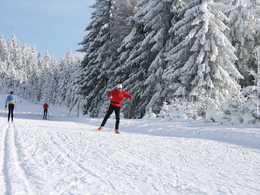
Hochficht cross-country ski run


- Flatly
- Possible accommodation
Interactive elevation profile
Create PDF
Tour-Details
Path number: 9
Starting place: 4161 Ulrichsberg
Destination: 4161 Ulrichsberg
duration: 2h 30m
length: 14,8 km
Altitude difference (uphill): 341m
Altitude difference (downhill): 341m
Lowest point: 924m
Highest point: 1.100m
difficulty: difficult
condition: very difficult
panoramic view: Some Views
Paths covering:
snow
powered by TOURDATA
Trail not in operation
The hardest cross-country skiing track in the Bohemian Forest nordic centre.Advantages of the Nordic Centre Böhmerwald - Schöneben entrance:
- Ski hire on site
- Cross-country skiing courses
- SpiLo (play trail) for children with ski jump, wave tracks, gate run and much more.
- Showers, changing rooms and sanitary facilities directly at the cross-country skiing centre
- Restaurant
- Road underpass
Request our free cross-country ski trail map here!
We would be happy to add you to our mailing list for the daily cross-country ski trail report - just send us a short e-mail: info@boehmerwald.at!
In winter, depending on snow conditions and weather.
Parking
- Parking space: 200
- Bus parking space: 10
Most economical season
- Deep winter
Please get in touch for more information.
Markt 28
4161 Ulrichsberg
Phone +43 5 7890 - 100
Fax machine +43 5 7890 - 115
E-Mail info@boehmerwald.at
Web www.boehmerwald.at
https://www.boehmerwald.at
You can also visit us on
Visit us on Facebook Visit us on Instagram Visit our videochannel on YouTube")
")
")
Interactive elevation profile
Create PDF
Tour-Details
Path number: 9
Starting place: 4161 Ulrichsberg
Destination: 4161 Ulrichsberg
duration: 2h 30m
length: 14,8 km
Altitude difference (uphill): 341m
Altitude difference (downhill): 341m
Lowest point: 924m
Highest point: 1.100m
difficulty: difficult
condition: very difficult
panoramic view: Some Views
Paths covering:
snow
powered by TOURDATA
