On the way to deceleration: pure summit (h) nut in 4 days on 71 km


- Multi-day tour
- Flatly
- Possible accommodation
Interactive elevation profile
Create PDF
Tour-Details
Path number: Gelbe Schilder mit Entschleunigungs-Symbol
Starting place: 4160 Aigen-Schlägl
Destination: 4160 Aigen-Schlägl
duration: 21h 4m
length: 70,7 km
Altitude difference (uphill): 1.982m
Altitude difference (downhill): 1.980m
Lowest point: 550m
Highest point: 1.370m
difficulty: medium
condition: medium
panoramic view: Great panorama
Paths covering:
Asphalt, Path / trail, Gravel, Hiking trail, Other
powered by TOURDATA
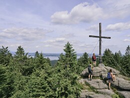
Pure summit pleasure in 4 days on 71 km Along the Große Mühl you enjoy a relaxed first day as a start to your summit adventure. On the following days, you will hike to a new summit on the Šumava ridge at over 1000 metres every day: Plöckenstein, Stinglfelsen, Bärenstein
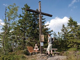
Enjoy the different panoramic views, pause at the highest points in the Mühlviertel and recharge your batteries at these special places of strength.
Did you know that the forest develops its very own forest climate? Take deep breaths of the oxygen-rich forest air filtered by the trees and strengthen your immune system.
Stage 1: Aigen-Schlägl - Schwarzenberg 19 km
Stage 2: Schwarzenberg - Holzschlag 21 km
Stage 3: Holzschlag - Hintenberg 16 km
Stage 4: Hintenberg - Aigen-Schlägl 14 km
Note: You should wear good shoes for the 2nd stage! This is a challenging stage. The descent after the Plöckenstein is difficult.
You can find the route digitally in the App Komoot.
On request, we will also be happy to provide you with a detailed description of the individual stages. This is also available for download under Multimedia/Documents.With the free outdooractive app, you can hike the route using navigation.
Starting point: Schlägl Abbey in Aigen-Schlägl.
Destination: Schlägl Abbey in Aigen-Schlägl.
further information:
- Multi-day tour
- Flatly
- Possible accommodation
- Experience of nature
- Board possible
1 May until 31 October
Accessibility / arrival
Directions Aigen-Schlägl
Westautobahn - Linz - B 127
Via Munich - Landshut - A92 - Deggendorf - Passau A3 - Exit
North via Wegscheid
Via Nuremberg - Regensburg A3 - Passau - exit north via Wegscheid
- Suitable for single travelers
- Suitable for couples
- Spring
- Summer
- Autumn
Please get in touch for more information.
Hauptstraße 2
4160 Aigen-Schlägl
Phone +43 5 7890 - 100
Fax machine +43 5 7890 - 115
E-Mail info@boehmerwald.at
Web www.wegderentschleunigung.at
https://www.wegderentschleunigung.at
You can also visit us on
Visit us on Facebook Visit us on Instagram Visit our videochannel on YouTube")
")
Interactive elevation profile
Create PDF
Tour-Details
Path number: Gelbe Schilder mit Entschleunigungs-Symbol
Starting place: 4160 Aigen-Schlägl
Destination: 4160 Aigen-Schlägl
duration: 21h 4m
length: 70,7 km
Altitude difference (uphill): 1.982m
Altitude difference (downhill): 1.980m
Lowest point: 550m
Highest point: 1.370m
difficulty: medium
condition: medium
panoramic view: Great panorama
Paths covering:
Asphalt, Path / trail, Gravel, Hiking trail, Other
powered by TOURDATA
