Falkensteiner Weg 110 / Rupertiweg E10, Teilstück im Mühlviertel


- pets allowed
- All weather
- Suitable for families
- culturally interesting
- Multi-day tour
- Possible accommodation
Interactive elevation profile
Create PDF
Tour-Details
Trail
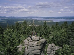
From the Bohemian Forest via the Hausruck and Kobernaußer Wald to the Salzach: The trail starts at Bärenstein (1077 m) near the Czech border, from where it runs through the villages of Aigen and Schlägl and via Peilstein to Oberkappel. Now the trail splits into the Innviertelweg route and the alternative route Inn-/Salzachuferweg (approx. 45 km).
Innviertelweg: From Oberkappel on the Falkensteinerweg along the Rannastausee, via Altenhof and the Falkenstein ruins to Niederranna a.d. Donau. After crossing the Danube, head up into the Hörzingerwald forest, then via Zell a.d. Pram to Haag am Hausruck. Now through the Hausruckwald forest and the Kobernaußerwald forest to the lovely pilgrimage site of Maria Schmolln and via Mattighofen, Eggelsberg and through the Ibmer Moor to Ostermiething, where the alternative route rejoins the Innviertelweg (approx. 170 km.).
Alternative route Inn-Salzach-Uferweg: Ostermiething can also be reached from Oberkappel through the Sauwald forest to the Inn or along its banks via Schärding am Inn, Antiesenhofen, Reichersberg am Inn, the border town of Braunau am Inn and St. Radegund. Radegund (approx. 160 km).
With the free outdooractive app, you can hike the trail using navigation.
further information:
- Multi-day tour
- Possible accommodation
- Board possible
- All weather
- Suitable for groups
- Pets allowed
- Suitable for seniors
- Suitable for single travelers
- Suitable for friends
- Suitable for couples
- Spring
- Summer
- Autumn
Please get in touch for more information.
Hauptstraße 2
4160 Aigen-Schlägl
Phone +43 5 7890 - 100
E-Mail info@boehmerwald.at
Web www.boehmerwald.at
Web www.alpenverein.at/weitwanderer/wei…
https://www.alpenverein.at/weitwanderer/weitwanderwege/rupertiweg.php
You can also visit us on
Visit us on Facebook Visit us on Instagram Visit our videochannel on YouTubeInteractive elevation profile
Create PDF
