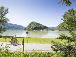
Rennradtour Donautal


- Flatly
- Possible accommodation
Interactive elevation profile
Create PDF
Tour-Details
Starting place: 4160 Aigen-Schlägl
Destination: 4160 Aigen-Schlägl
duration: 6h 0m
length: 79,0 km
Altitude difference (uphill): 1.374m
Altitude difference (downhill): 1.381m
Lowest point: 276m
Highest point: 735m
difficulty: medium
condition: medium
panoramic view: Great panorama
Paths covering:
Asphalt
powered by TOURDATA
Varied journey into the Danube valley with the Schlögener Schlinge.
0 km This tour starts in Aigen-Schlägl. Via Bahnhofstraße and further along Baureitherstraße you reach Baureith and the Schlägler Bezirksstraße, which takes you through several small villages to
10 km Haslach an der Mühl.From Linzerstraße you reach the Haslacher Bezirksstraße. Climbing steadily, you reach Neudorf and Kasten
24 km St.Peter am Wimberg. Passing hop fields via Pehersdorf and Drautendorf, you reach the B127. Cross the roundabout, follow Windorfstraße for approx. 1 km and turn right towards Plöcking. Via Neuhaus the route goes downhill into the Danube valley to
40 km Untermühl. Follow the Danube upstream and reach Obermühl via Exlau. From here you cycle uphill again in the valley of the Kleine Mühl. Via Tannberg, Hühnergeschrei and Sprinzenstein you
68 km Rohrbach-Berg. Keep left at the town square, Bahnhofstraße takes
you out of town. At the end of the town centre, turn right and follow the road via Hehenberg towards Öpping. Shortly before Öpping railway station, turn right and after approx. 500 m you will reach the B127. Turn right again and follow the main road to your starting point
79 km Aigen-Schlägl.
Use the free outdooractive app to navigate the route.
Most economical season
- Spring
- Summer
- Autumn
Please get in touch for more information.
Hauptstraße 2
4160 Aigen-Schlägl
Phone +43 5 7890 - 100
Fax machine +43 5 7890 - 115
E-Mail info@boehmerwald.at
Web www.boehmerwald.at
Web www.almesberger.at
https://www.boehmerwald.at
https://www.almesberger.at
https://www.almesberger.at
You can also visit us on
Visit us on Facebook Visit us on Instagram Visit our videochannel on YouTubeInteractive elevation profile
Create PDF
Tour-Details
Starting place: 4160 Aigen-Schlägl
Destination: 4160 Aigen-Schlägl
duration: 6h 0m
length: 79,0 km
Altitude difference (uphill): 1.374m
Altitude difference (downhill): 1.381m
Lowest point: 276m
Highest point: 735m
difficulty: medium
condition: medium
panoramic view: Great panorama
Paths covering:
Asphalt
powered by TOURDATA


