Legend trail


- Suitable for pushchairs
- Flatly
- Possible accommodation
Interactive elevation profile
Create PDF
Tour-Details
Path number: 26
Starting place: 4163 Klaffer am Hochficht
Destination: 4163 Klaffer am Hochficht
duration: 1h 30m
length: 5,5 km
Altitude difference (uphill): 37m
Altitude difference (downhill): 40m
Lowest point: 598m
Highest point: 635m
difficulty: easy
condition: easy
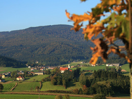
panoramic view: Great panorama
Paths covering:
Hiking trail
powered by TOURDATA
Along the trail, 19 display boards tell legends from the region. In addition, the trail leads around the Urlsee, which is also a fishing and plant nature trail. The loop is also passable with a pram!
0 km The starting point is in the local centre of Klaffer am Hochficht (car park in front of the municipal office). You walk in the direction of ...
400 m church. Before the church entrance, take the path to the right along the fence and walk parallel to the chapel path past the ...
490 m herb garden. After approx. 100 metres, you will see the Pechölstein on the right-hand side of the Sonnenweg. Turn right and walk along the southern slope of Klaffer to Mühltalweg. Continue left here. Now a field path begins, which turns into a forest path. You walk through the short section of forest and the romantic river "Große Mühl" accompanies you.
On reaching the tarmac road, leave the Kapellenweg. Continue to the right. Shortly afterwards, the Seeweg = access road to the bathing lake and campsite branches off. However, you continue straight ahead. Soon afterwards you turn left onto the Seerosenweg. A beautiful country lane begins. On the left is the idyllic...
2.6 km bathing lake of Klaffer and you can take a look there. You will soon reach the ...
2.9 km Urlsee. This is also the turn-off to the Mühl-fun quarter. (A project of the Kinderfreunde Mühlviertel. It is for families, young people and children who want to relax, learn something or take advantage of the wide range of adventure and entertainment on offer). Take this turn-off and then take the path around the Urlsee lake, which is also a fishing and plant nature trail.
4.1 km After the loop, continue left and shortly afterwards you will reach the B127 road from Klaffer to Schwarzenberg. Walk 200 metres along the pavement before crossing the road and turning left into the business park. At the crossroads immediately afterwards, continue the hike to the right. On the northern side of Klaffer, walk to the ...
5.3 km carp pond, where you might be lucky enough to see a large carp swimming. The path now leads you uphill back to the ...
5.7 km starting point.
Request our hiking map for EUR 3.00!
With the free outdooractive app, you can hike the trail using navigation.
Starting point: Klaffer am Hochficht town square, car park in front of the municipal office.
Destination: Klaffer am Hochficht town square, car park in front of the municipal office.
further information:
- Flatly
- Possible accommodation
- Board possible
Details - hiking
- themed path
- Suitable for pushchairs
- Spring
- Summer
- Autumn
Please get in touch for more information.
Dorfplatz 1
4163 Klaffer am Hochficht
Phone +43 5 7890 - 100
Fax machine +43 5 7890 - 115
E-Mail info@boehmerwald.at
Web www.boehmerwald.at/
https://www.boehmerwald.at/
You can also visit us on
Visit us on Facebook Visit us on Instagram Visit our videochannel on YouTube")
")
")
")
")
")
Interactive elevation profile
Create PDF
Tour-Details
Path number: 26
Starting place: 4163 Klaffer am Hochficht
Destination: 4163 Klaffer am Hochficht
duration: 1h 30m
length: 5,5 km
Altitude difference (uphill): 37m
Altitude difference (downhill): 40m
Lowest point: 598m
Highest point: 635m
difficulty: easy
condition: easy
panoramic view: Great panorama
Paths covering:
Hiking trail
powered by TOURDATA
