Maple Round Path


- culturally interesting
- Flatly
Interactive elevation profile
Create PDF
Tour-Details
Path number: 88
Starting place: 4184 Helfenberg
Destination: 4184 Helfenberg
duration: 1h 30m
length: 4,4 km
Altitude difference (uphill): 135m
Altitude difference (downhill): 138m
Lowest point: 748m
Highest point: 860m
difficulty: easy
condition: easy
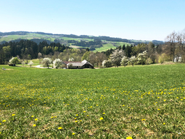
panoramic view: Great panorama
Paths covering:
Asphalt, Hiking trail
powered by TOURDATA
The starting point is at the Ahorn nature factory next to the Ziegelstadel, which is one of the oldest buildings in the area. Highlights of this hiking trail are Piberstein Castle, which can also be chosen as the starting point, as well as recurring magnificent views of the Mühlviertel hills.
0 km You start the hike at the car park of the Naturfabrik Ahorn and take the path through the village of Ahorn. The Ziegelstadel is one of the oldest buildings in the area. It was first mentioned in a document in 1147.
The Ahorn circular trail now follows the road downhill for a short distance, where you are treated to a magnificent view, even as far as the Alps on a clear day. At the bend, leave the road in a westerly direction and turn right onto the field path, which initially leads steeply downhill and along a ridge.
You reach a fork in the path, where you turn right and pass the beautiful Grillenberger Gut estate. You walk towards the forest and cross it on a slightly ascending path.
At the clearing, walk towards the houses in front of you. You now follow the tarmac access road, cross a small section of forest and reach the road that comes from Helfenberg and leads to Ahorn.
Here you take the 5-10 minute detour to Piberstein Castle. It's worth it, as you can enjoy a wonderful view from the west side of the castle far into the hilly Mühlviertel region.
2.5 km The Piberstein Castle was built around 1200 by the brothers Ruga and Arnold von Piber as a late Gothic tower castle. The Piber family died out in 1364 and the castle changed hands several times. In 1894, the castle passed into the possession of Countess Olimpia Revertera, the great-grandmother of the current owner.
In recent years, the castle has been renovated thanks to the joint commitment of the owner, the municipalities and associations, as well as the generous support of the Cultural Office of the Upper Austrian Provincial Government. provincial government, the castle has been renovated. Every year, the Piberstein Cultural Association organises the Cultural Summer in the historic setting.
Now walk back the 5-10 minute detour and follow the signposts that lead you right into the forest. The Burgweg, which has accompanied you for this short stretch from the castle, leaves us in the direction of Altenschlag.
Now you can expect a steep climb through the forest lasting around 15 minutes. Once you reach the top, you can rest on the bench and enjoy the beautiful view. Pass the farmstead on the left and briefly follow the access road before continuing along the dirt track on the right until you reach the...
4.4 km starting point
Request our hiking map for EUR 3.00!
With the free app outdooractive you can hike the trail by navigation.
Starting point: Natural Maple Factory.
Destination: Natural Maple Factory.
further information:
- Flatly
Most economical season
- Spring
- Summer
- Autumn
Please get in touch for more information.
Leonfeldner Straße 15
4184 Helfenberg
Phone +43 5 7890 - 100
Fax machine +43 5 7890 - 115
E-Mail info@boehmerwald.at
Web www.boehmerwald.at
https://www.boehmerwald.at
You can also visit us on
Visit us on Facebook Visit us on Instagram Visit our videochannel on YouTube")
")
Interactive elevation profile
Create PDF
Tour-Details
Path number: 88
Starting place: 4184 Helfenberg
Destination: 4184 Helfenberg
duration: 1h 30m
length: 4,4 km
Altitude difference (uphill): 135m
Altitude difference (downhill): 138m
Lowest point: 748m
Highest point: 860m
difficulty: easy
condition: easy
panoramic view: Great panorama
Paths covering:
Asphalt, Hiking trail
powered by TOURDATA
