
Winterwanderweg: Schöneben-Hochficht


- Possible accommodation
Interactive elevation profile
Create PDF
Tour-Details
Starting place: 4161 Ulrichsberg
Destination: 4161 Ulrichsberg
duration: 4h 0m
length: 12,0 km
Altitude difference (uphill): 132m
Altitude difference (downhill): 133m
Lowest point: 908m
Highest point: 974m
difficulty: medium
condition: medium
panoramic view: Some Views
Paths covering:
snow
powered by TOURDATA
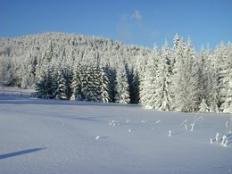
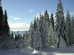
Winter hiking trail offering a wonderful view of the Bohemain Forest vacation area.
With the free outdooractive app, you can hike the trail using navigation.
further information:
- Possible accommodation
- Board possible
Details - hiking
- cleared winter hiking path
Parking
- Parking space: 50
Most economical season
- Deep winter
Please get in touch for more information.
Markt 28
4161 Ulrichsberg
Phone +43 5 07263 - 200
E-Mail boehmerwald@muehlviertel.at
Web www.muehlviertel.at/
https://www.muehlviertel.at/
You can also visit us on
Visit us on Facebook Visit us on Instagram Visit our videochannel on YouTube
")

")
")
Interactive elevation profile
Create PDF
Tour-Details
Starting place: 4161 Ulrichsberg
Destination: 4161 Ulrichsberg
duration: 4h 0m
length: 12,0 km
Altitude difference (uphill): 132m
Altitude difference (downhill): 133m
Lowest point: 908m
Highest point: 974m
difficulty: medium
condition: medium
panoramic view: Some Views
Paths covering:
snow
powered by TOURDATA
