Rohrbach riddle trail


- Suitable for families
- Flatly
Interactive elevation profile
Create PDF
Tour-Details
Starting place: 4150 Rohrbach-Berg
Destination: 4150 Rohrbach-Berg
duration: 1h 4m
length: 3,5 km
Altitude difference (uphill): 105m
Altitude difference (downhill): 103m
Lowest point: 593m
Highest point: 693m
difficulty: easy
condition: very easy
panoramic view: Individual Views
Paths covering:
Path / trail, Gravel, Street, Hiking trail
powered by TOURDATA
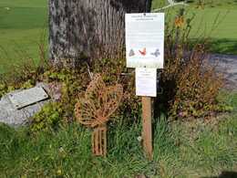
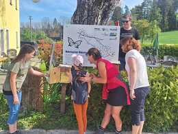
The Rohrbach puzzle trail invites children to a treasure hunt where they can collect interesting information on an exciting topic. The Healthy Community of Rohrbach-Berg and the Böhmerwald Tourism Association have launched an exciting hiking and puzzle campaign for the season from May to October 2024, centred around the idyllic Mosthütte snack station. This year is all about the butterfly. Friends of nature and hiking enthusiasts are invited to explore the surrounding area and learn more about these fascinating insects.
With the free outdooractive app, you can hike the trail using navigation.
With the free outdooractive app, you can hike the trail using navigation.
Starting point: Mosthütte snack station.
Destination: Mosthütte snack station.
further information:
- Flatly
- Board possible
Details - hiking
- themed path
- Suitable for children
- Spring
- Summer
- Autumn
Please get in touch for more information.
Stadtplatz 1
4150 Rohrbach-Berg
Phone +43 5 7890 - 100
Fax machine +43 5 7890 - 115
E-Mail info@boehmerwald.at
Web www.boehmerwald.at/
https://www.boehmerwald.at/
")

Interactive elevation profile
Create PDF
Tour-Details
Starting place: 4150 Rohrbach-Berg
Destination: 4150 Rohrbach-Berg
duration: 1h 4m
length: 3,5 km
Altitude difference (uphill): 105m
Altitude difference (downhill): 103m
Lowest point: 593m
Highest point: 693m
difficulty: easy
condition: very easy
panoramic view: Individual Views
Paths covering:
Path / trail, Gravel, Street, Hiking trail
powered by TOURDATA
