Kurze Rennradrunde durchs Mühlviertel


Interactive elevation profile
Create PDF
Tour-Details
Starting place: 4160 Aigen-Schlägl
Destination: 4160 Aigen-Schlägl
duration: 4h 0m
length: 49,5 km
Altitude difference (uphill): 975m
Altitude difference (downhill): 982m
Lowest point: 500m
Highest point: 784m
difficulty: easy
condition: easy
panoramic view: Dreamtour
Paths covering:
Asphalt
powered by TOURDATA
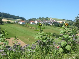
Short but impressive road bike tour through the enchanting holiday region of the Bohemian Forest.
The tour starts in Aigen-Schlägl and spoils cyclists with marvellous views up to the Bohemian Forest, over the valleys of the Große and Kleine Mühl. There are also plenty of enjoyable cycle rest stops. There are plenty of inviting places to stop for refreshments along the route.
Use the free outdooractive app to navigate the route.
")
")
Most economical season
- Spring
- Summer
- Autumn
Please get in touch for more information.
Hauptstraße 2
4160 Aigen-Schlägl
Phone +43 5 7890 - 100
Fax machine +43 5 7890 - 115
E-Mail info@boehmerwald.at
Web www.boehmerwald.at
Web www.almesberger.at
https://www.boehmerwald.at
https://www.almesberger.at
https://www.almesberger.at
You can also visit us on
Visit us on Facebook Visit us on Instagram Visit our videochannel on YouTubeInteractive elevation profile
Create PDF
Tour-Details
Starting place: 4160 Aigen-Schlägl
Destination: 4160 Aigen-Schlägl
duration: 4h 0m
length: 49,5 km
Altitude difference (uphill): 975m
Altitude difference (downhill): 982m
Lowest point: 500m
Highest point: 784m
difficulty: easy
condition: easy
panoramic view: Dreamtour
Paths covering:
Asphalt
powered by TOURDATA
