


Power Source Tree


- Multi-day tour
- Flatly
- Possible accommodation
Interactive elevation profile
Create PDF
Tour-Details
Paths covering:
On your own with our trees
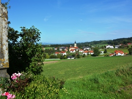
The 60 km circular trail is dedicated to the topic of "tree healing". Thirty boards provide information about the healing power, mythology and effects of trees. Basically, tree medicine heals with the vitality of trees. However, plant parts are also used in folk medicine, homeopathy, Bach flower therapy and, of course, in traditional European medicine.
The oak leaf was chosen as the symbol of the trail, as the oak symbolises strength and endurance.
The circular hiking trail with a total length of around 60 km is ideal for walking in three days with stages of around 20 km. If you prefer, you can of course also hike the trail in two days. Overnight accommodation options along the route allow you to customise your hike. If you prefer to stay overnight with a single host, you can take a taxi to the respective starting point or be picked up from the end point of each stage.Various sights invite you to visit and linger. Some of them are freely accessible, such as the Waxenberg castle ruins and the Wendenstein. If you would like a guided tour and visit (Piberstein Castle, Unterkagererhof monument farm), please contact the responsible operators in advance and make an appointment. The chancel of the Maria Rast forest chapel can be viewed from the outside. Around five minutes away from the forest chapel - follow the signs - you will find the source of the "holy water", which is said to help with eye problems in particular. The water springs from the lap of a statue of the Virgin Mary in a wooden spring house.
Five rest areas were created along the trail in 2019: "Am Pesenbach", "Des Wissens", "In der Wiese", "Im Schatten der Buche" and "Mit Weitblick". These beautiful places invite you to linger and take in nature with all its sounds and smells. As a memento of this moment, everyone is welcome to take home a postcard, which is kept in a box on site.
With the free outdooractive app, you can hike / drive along the trail using navigation.
further information:
- Multi-day tour
- Flatly
- Possible accommodation
- Board possible
Details - hiking
- themed path
From Linz on the B127 to Gerling, turn right to Herzogsdorf, continue to St.Johann.
Mühlkreisbahn to Neufelden station - approx. 12km to St.Johann.
The tour can also be started in the surrounding villages.
- Spring
- Summer
- Autumn
Please get in touch for more information.
St. Johann 10
4172 St. Johann am Wimberg
Phone +43 7217 7155 - 13
E-Mail renate.ehrenmueller@stjohannamwimberg.at
Web www.hansbergland.at
You can also visit us on
Visit us on Facebook Visit us on Instagram Visit our videochannel on YouTube")
")
")
")

")
")
")
")
")
")
")
")

")
")
")
")

")
")
")
")
")


Interactive elevation profile
Create PDF
Tour-Details
Paths covering:
