 Mühlviertel Marken GmbH, Hochhauser.")
 Mühlviertel Marken GmbH, Hochhauser.")
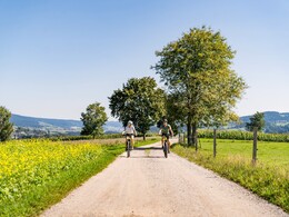
Mühltal Cycle Route


- Flatly
- Possible accommodation
Interactive elevation profile
Create PDF
Tour-Details
Path number: 806
Starting place: 4163 Klaffer am Hochficht
Destination: 4163 Klaffer am Hochficht
duration: 4h 0m
length: 37,1 km
Altitude difference (uphill): 600m
Altitude difference (downhill): 600m
Lowest point: 530m
Highest point: 770m
difficulty: medium
condition: medium
panoramic view: Great panorama
Paths covering:
Asphalt, Gravel
powered by TOURDATA
Route through the wonderful hills of the Böhmerwald and Mühlviertel holiday region! 0 km The starting point is the local square in Klaffer am Hochficht. Don't miss the fragrant healing herb garden next to the church. Take the main road via Salnau to...
3.5 km to Ulrichsberg. Turn right at the roundabout towards the village. Immediately afterwards, follow the signs to the right towards Golfpark. At the Dreihans company, head towards Berdetschlag. After 700 metres, leave the road and follow the Schwarzholz goods road (pretty chapel). Continue straight on to...
7 km Seitelschlag. At the chestnut tree in the village, take the left-hand path and cycle through the village.
7.5 km You cycle on to Golfpark Böhmerwald. The path descends past the Julbacher Häusln houses to the district road. Keep left and continue to...
10.5 km Julbach. Follow the main road. Turn right at the fire station and continue past the outdoor pool to...
13.6 km Niederkraml. Cross the village and follow the tarmac road to...
15.7 km Exenschlag. After around 300 m, turn right at the "Lindorfer-Eder" sign and follow the goods road to...
16.9 km Bauernhof Lindorfer. There is a 3D archery course here! Take the gravel road uphill through the forest, which leads past the house on the left. Shortly afterwards, you will reach the tarmac road...
17.7 km to Emsmannsreit. Shortly afterwards, turn right onto the farm track that crosses the road and then immediately turn left again. Cycling first along the field path and then along the forest path, you will soon reach the Nebelberg estate road. Turn right. The route now climbs moderately to...
19.3 km Vordernebelberg. Cycle through the village. After the end of the village, a narrow, winding tarmac road (garages on the right) leads down into the valley and back up the opposite slope to...
20.8 km Nebelberg. Turn left. Leave the main road again and follow the signpost on the right to Heinrichsberg and Stift am Grenzbach. The R5 country cycle path now accompanies you. Keep straight ahead. This is followed by a very scenic section with few climbs through meadows and woodland close to the Bavarian border. A short ascent through the forest begins in the wasteland near the Hellauer farm butcher's shop. Once you reach the top, a wonderful view of the Bohemian Forest opens up before you. You soon reach...
25.4 km Kohlstatt. Cycle right along the Hinterschiffl estate road to...
26.4 km Schifflerkapelle, where you turn left onto the Kriegwald estate road and then take the Bräuerau estate road to the right. It goes downhill. At the junction with the...
29.8 km road to Julbach, cross it and follow the signpost "Ulrichsberg 6 km". Shortly afterwards, turn left onto a forest path, always parallel to the R5. At the end of the forest, cross the...
32.8 km river "Große Mühl". At the crossroads, turn right onto the tarmac road. Immediately afterwards, turn right again onto the dirt track to Vorderanger (scattered settlement). Here you can cool off in the nearby bathing lake. A short climb leads over the southern slope of the village back to your...
36.8 km starting point Klaffer am Hochficht.
Request our cycle map for EUR 3.00!
Use the free outdooractive app to navigate the route.
Starting point: Klaffer am Hochficht town square.
Destination: Klaffer am Hochficht town square.
further information:
- Flatly
- Possible accommodation
- Board possible
Most economical season
- Spring
- Summer
- Autumn
Please get in touch for more information.
Dorfplatz 1
4163 Klaffer am Hochficht
Phone +43 5 7890 - 100
Fax machine +43 5 7890 - 115
E-Mail info@boehmerwald.at
Web www.boehmerwald.at/
https://www.boehmerwald.at/
You can also visit us on
Visit us on Facebook Visit us on Instagram Visit our videochannel on YouTube
")
")
")
")
")
Interactive elevation profile
Create PDF
Tour-Details
Path number: 806
Starting place: 4163 Klaffer am Hochficht
Destination: 4163 Klaffer am Hochficht
duration: 4h 0m
length: 37,1 km
Altitude difference (uphill): 600m
Altitude difference (downhill): 600m
Lowest point: 530m
Highest point: 770m
difficulty: medium
condition: medium
panoramic view: Great panorama
Paths covering:
Asphalt, Gravel
powered by TOURDATA
