Wanderreitroute Böhmerwald - Wegscheid


Interactive elevation profile
Create PDF
Tour-Details
Starting place: 4164 Schwarzenberg am Böhmerwald
Destination: 4154 Kollerschlag
duration: 3h 0m
length: 27,0 km
Altitude difference (uphill): 479m
Altitude difference (downhill): 630m
Lowest point: 593m
Highest point: 808m
difficulty: medium
condition: medium
panoramic view: Great panorama
Paths covering:
Asphalt, Path / trail
powered by TOURDATA
Trail connection Bavaria - Bohemian Forest - Wegscheid
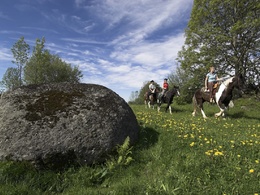
This trail riding tour takes you through deep forests alternating with meadows and farmland. The charming hilly landscape of the Bohemian Forest will inspire you with its ever-changing marvellous views.
Connection from Schwarzenberg via Julbach, Kohlstatt, Kollerschlag to Wegscheid.
This trail riding tour takes you through deep forests alternating with meadows and farmland. The charming hilly landscape of the Bohemian Forest will inspire you with its ever-changing marvellous views.
Connection from Schwarzenberg via Julbach, Kohlstatt, Kollerschlag to Wegscheid.
Details riding
Most economical season
- Spring
- Summer
- Autumn
Please get in touch for more information.
Hauptstraße 4
4164 Schwarzenberg am Böhmerwald
Phone +43 5 7890 - 100
Fax machine +43 5 7890 - 115
E-Mail info@boehmerwald.at
Web www.boehmerwald.at
https://www.boehmerwald.at
You can also visit us on
Visit us on Facebook Visit us on Instagram Visit our videochannel on YouTube")
")

")
Interactive elevation profile
Create PDF
Tour-Details
Starting place: 4164 Schwarzenberg am Böhmerwald
Destination: 4154 Kollerschlag
duration: 3h 0m
length: 27,0 km
Altitude difference (uphill): 479m
Altitude difference (downhill): 630m
Lowest point: 593m
Highest point: 808m
difficulty: medium
condition: medium
panoramic view: Great panorama
Paths covering:
Asphalt, Path / trail
powered by TOURDATA
