Winterwanderweg: Psalmenweg


- culturally interesting
- Flatly
- Possible accommodation
Interactive elevation profile
Create PDF
Tour-Details
Starting place: 4150 Rohrbach-Berg
Destination: 4150 Rohrbach-Berg
duration: 1h 0m
length: 3,4 km
Altitude difference (uphill): 92m
Altitude difference (downhill): 91m
Lowest point: 593m
Highest point: 685m
difficulty: easy
condition: easy
panoramic view: Great panorama
Paths covering:
snow
powered by TOURDATA
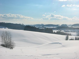
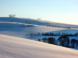
Enjoy every step in the wintery Bohemian Forest vacation area.
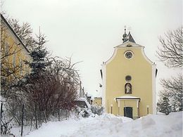
Along the way, 11 stations with verses from the Psalms will inspire you to meditate. The hike begins at the Dreispitz at the start of the Way of the Cross. Follow the high path towards the Plague Column, continue over the Pfaffenberg and on to the Liberation Cross. After the 2nd plague column, descend, cross the railway tracks, continue on the path and cross the railway tracks again, turn left towards the forest. Follow the forest road through the Berger forest. At the edge of the forest, the path turns right uphill and leads out of the forest after a short ascent. Turn right uphill towards the 3rd plague column. After a few steps, turn right onto a narrow path that leads you to the Maria Trost pilgrimage church. Take the road downhill back to the starting point.
With the free outdooractive app, you can hike the trail using navigation.
further information:
- Flatly
- Possible accommodation
- Board possible
Details - hiking
- cleared winter hiking path
Most economical season
- Deep winter
Please get in touch for more information.
Stadtplatz 1
4150 Rohrbach-Berg
Phone +43 5 7890 - 100
Fax machine +43 5 7890 - 115
E-Mail info@boehmerwald.at
Web www.boehmerwald.at
https://www.boehmerwald.at
You can also visit us on
Visit us on Facebook Visit us on Instagram Visit our videochannel on YouTube
Interactive elevation profile
Create PDF
Tour-Details
Starting place: 4150 Rohrbach-Berg
Destination: 4150 Rohrbach-Berg
duration: 1h 0m
length: 3,4 km
Altitude difference (uphill): 92m
Altitude difference (downhill): 91m
Lowest point: 593m
Highest point: 685m
difficulty: easy
condition: easy
panoramic view: Great panorama
Paths covering:
snow
powered by TOURDATA
