Kleiner Mühltalweg


- pets allowed
- All weather
- Flatly
Interactive elevation profile
Create PDF
Tour-Details
Path number: 23
Starting place: 4121 Altenfelden
Destination: 4121 Altenfelden
duration: 3h 39m
length: 12,2 km
Altitude difference (uphill): 330m
Altitude difference (downhill): 335m
Lowest point: 440m
Highest point: 599m
difficulty: medium
condition: medium
panoramic view: Some Views
Paths covering:
Asphalt, Hiking trail, Other
powered by TOURDATA
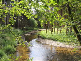
Route for more demanding hikers. ROUTENVERLAUF: From the market square via Godersdorf (Dreinischenkapelle), Leitenbauer and Doppl along the Kleine Mühltal to Hühnergeschrei. From there it goes via Stein to Schweinsberg (619 m). The trail continues via Grubhäusl and Kainberg back to Altenfelden.
SIGHTPOINTS: Dreinischenkapelle, Stein, Schweinzberg
SIGHTPOINTS: Dreinischenkapelle, Kleine Mühltalbrücke
With the free outdooractive app, you can hike the trail using navigation.
SIGHTPOINTS: Dreinischenkapelle, Stein, Schweinzberg
SIGHTPOINTS: Dreinischenkapelle, Kleine Mühltalbrücke
With the free outdooractive app, you can hike the trail using navigation.
- All weather
- Pets allowed
- Spring
- Summer
- Autumn
Please get in touch for more information.
Veldenstraße 3
4121 Altenfelden
Phone +43 5 7890 - 100
E-Mail info@boehmerwald.at
Web www.boehmerwald.at
https://www.boehmerwald.at
You can also visit us on
Visit us on Facebook Visit us on Instagram Visit our videochannel on YouTubeInteractive elevation profile
Create PDF
Tour-Details
Path number: 23
Starting place: 4121 Altenfelden
Destination: 4121 Altenfelden
duration: 3h 39m
length: 12,2 km
Altitude difference (uphill): 330m
Altitude difference (downhill): 335m
Lowest point: 440m
Highest point: 599m
difficulty: medium
condition: medium
panoramic view: Some Views
Paths covering:
Asphalt, Hiking trail, Other
powered by TOURDATA
