Lauf & Nordic Walking Rundweg Böhmerwaldpark


- Flatly
Interactive elevation profile
Create PDF
Tour-Details
Starting place: 4161 Ulrichsberg
Destination: 4161 Ulrichsberg
duration: 0h 48m
length: 3,3 km
Altitude difference (uphill): 51m
Altitude difference (downhill): 52m
Lowest point: 641m
Highest point: 698m
difficulty: easy
condition: easy
panoramic view: Individual Views
Paths covering:
Asphalt, Gravel, Hiking trail
powered by TOURDATA
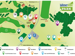
Easy running and Nordic walking tour in the Böhmerwaldpark.
0 km You start at the car park of Šumava Park. Next to the car park, walk along the gravel road. Then keep right and turn left into the forest. The forest path runs uphill.
0.5 km At the hill, turn right. From here it goes downhill again. You reach the road into which you turn right. At the crossroads, continue downhill to the left and turn right after approx. 300 metres. Pass the houses and turn left into the forest path.
The path now runs along the edge of the Böhmerwald Golf Park.
2.3 km You reach the gravel road, into which you turn right and cross part of the golf park.
2.8 km Turn left onto the asphalt road and return to your
3.3 km starting point.
With the free outdooractive app, you can hike the trail using navigation.
Parking
- Parking space: 50
Most economical season
- Spring
- Summer
- Autumn
Please get in touch for more information.
Seitelschlag 50
4161 Ulrichsberg
Phone +43 7288 8200
E-Mail info@boehmerwaldpark.at
Web www.boehmerwaldpark.at
https://www.boehmerwaldpark.at
You can also visit us on
Visit us on Facebook Visit us on Instagram Visit our videochannel on YouTube")

Interactive elevation profile
Create PDF
Tour-Details
Starting place: 4161 Ulrichsberg
Destination: 4161 Ulrichsberg
duration: 0h 48m
length: 3,3 km
Altitude difference (uphill): 51m
Altitude difference (downhill): 52m
Lowest point: 641m
Highest point: 698m
difficulty: easy
condition: easy
panoramic view: Individual Views
Paths covering:
Asphalt, Gravel, Hiking trail
powered by TOURDATA
