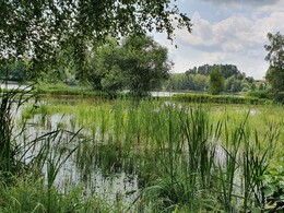
The path around the lake


Interactive elevation profile
Create PDF
Tour-Details
Path number: -
Starting place: 4163 Klaffer am Hochficht
Destination: 4163 Klaffer am Hochficht
duration: 0h 30m
length: 2,5 km
Altitude difference (uphill): 36m
Altitude difference (downhill): 36m
Lowest point: 600m
Highest point: 627m
difficulty: very easy
condition: very easy
panoramic view: Great panorama
Paths covering:
Asphalt, Gravel, Hiking trail
powered by TOURDATA
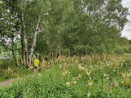
Procházka ke koupacímu jezeru Klaffer. Smyčka je průchozí i s kočárkem! V obou směrech je značena žlutými značkami! 0 km The starting point is in the local centre of Klaffer (car park in front of the municipal office). Turn left into the Wenibergstraße. After approx. 250 m turn left. Shortly afterwards, turn right into the forest and reach the ...
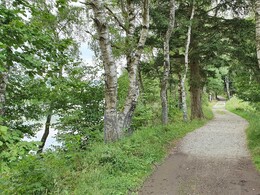
1 km access to the bathing lake and campsite. Here, the path forks into a longer and a shorter variant.* For the way back, turn into the Mühltalweg. Walk along the Große Mühl on the southern slope of Klaffer, initially on a forest path, which then turns into a meadow path. Turn right into Michlbergstraße, which takes you uphill back to the village centre and thus to your starting point.
*Connect the lake trail with the fishing and plant nature trail:
For the way back, walk along the water lily trail again and turn left onto the Mühltalweg at the entrance to the bathing lake. Walk along the Große Mühl on the southern slope of Klaffer, initially on a forest path, which then turns into a meadow path. Turn right onto Michlbergstraße this will take you uphill back to the village centre and thus to your ...
5.3 km starting point.
Request the hiking map of the region for EUR 3.00 here!
With the free outdooractive app, you can hike the trail using navigation.
1 km access to the bathing lake and campsite. Here, the path forks into a longer and a shorter variant.* For the way back, turn into the Mühltalweg. Walk along the Große Mühl on the southern slope of Klaffer, initially on a forest path, which then turns into a meadow path. Turn right into Michlbergstraße, which takes you uphill back to the village centre and thus to your starting point.
*Connect the lake trail with the fishing and plant nature trail:
- 1.5 hours | 5.3 km
For the way back, walk along the water lily trail again and turn left onto the Mühltalweg at the entrance to the bathing lake. Walk along the Große Mühl on the southern slope of Klaffer, initially on a forest path, which then turns into a meadow path. Turn right onto Michlbergstraße this will take you uphill back to the village centre and thus to your ...
5.3 km starting point.
Request the hiking map of the region for EUR 3.00 here!
With the free outdooractive app, you can hike the trail using navigation.
Starting point: Klaffer am Hochficht village centre, parking spaces in front of the municipal office.
Destination: Klaffer am Hochficht village centre, parking spaces in front of the municipal office.
further information:
- Board possible
Most economical season
- Spring
- Summer
- Autumn
- Early winter
Please get in touch for more information.
Dorfplatz 1
4163 Klaffer am Hochficht
Phone +43 5 7890 - 100
Fax machine +43 5 7890 - 115
E-Mail info@boehmerwald.at
Web www.boehmerwald.at
https://www.boehmerwald.at
You can also visit us on
Visit us on Facebook Visit us on Instagram Visit our videochannel on YouTube")
")
")
")
Interactive elevation profile
Create PDF
Tour-Details
Path number: -
Starting place: 4163 Klaffer am Hochficht
Destination: 4163 Klaffer am Hochficht
duration: 0h 30m
length: 2,5 km
Altitude difference (uphill): 36m
Altitude difference (downhill): 36m
Lowest point: 600m
Highest point: 627m
difficulty: very easy
condition: very easy
panoramic view: Great panorama
Paths covering:
Asphalt, Gravel, Hiking trail
powered by TOURDATA
