Julbach Pearl Trail


- Flatly
Interactive elevation profile
Create PDF
Tour-Details
Starting place: 4162 Julbach
Destination: 4162 Julbach
duration: 1h 0m
length: 2,2 km
Altitude difference (uphill): 98m
Altitude difference (downhill): 97m
Lowest point: 599m
Highest point: 701m
difficulty: easy
condition: easy
panoramic view: Great panorama
Paths covering:
Asphalt, Hiking trail
powered by TOURDATA
Přízemnost, spokojenost a důvěra v Boha jsou dobrým základem.
pro blahobyt lidí. "Perly" jsou nabídkou k nalezení klidu a vyrovnanosti.
The Julbacher Perlenweg invites you to actively hike, to think creatively and to experience things together. Hike from one pearl to the next. These pearls are special places along the trail. Information about the pearls can be found at each location.
Along the route you will find the parish church, the Way of the Cross on the Calvary, the Calvary Chapel, the newly built memorial square, the 10 Commandments Trail, the Peace Square, the Chapel of St Cecilia and the Poppgarten.
0 km Start at the parish church - the first pearl. Walk left uphill to the main road, which you cross. Follow the signs uphill and you will reach the ...
300 m entrance to the Way of the Cross, which you turn left onto. The stations of the Way of the Cross take you to the ...
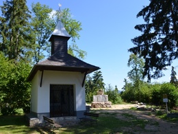
700 m Calvary Chapel and the associated memorial square. From here, the 10 Commandments Trail runs parallel. Walk slightly downhill along the forest path on the left until you reach the road. Follow this to the left for a few metres and turn right onto the field path. You will come to a road which you turn right into downhill and return to the start of the Way of the Cross. On the left, open the gate to the sheep pasture, which you cross. After the pasture, follow the path to ...
1,6 km Cäcilienkapelle. Continue along the path and turn right into the road. This will take you to the main road, which you turn right onto. Here you will reach the last gem of the trail, the Popp.Garten, and continue to your...
2.2 km starting point of Julbach parish church.
With the free outdooractive app, you can hike the trail using navigation.
pro blahobyt lidí. "Perly" jsou nabídkou k nalezení klidu a vyrovnanosti.
The Julbacher Perlenweg invites you to actively hike, to think creatively and to experience things together. Hike from one pearl to the next. These pearls are special places along the trail. Information about the pearls can be found at each location.
Along the route you will find the parish church, the Way of the Cross on the Calvary, the Calvary Chapel, the newly built memorial square, the 10 Commandments Trail, the Peace Square, the Chapel of St Cecilia and the Poppgarten.
0 km Start at the parish church - the first pearl. Walk left uphill to the main road, which you cross. Follow the signs uphill and you will reach the ...
300 m entrance to the Way of the Cross, which you turn left onto. The stations of the Way of the Cross take you to the ...
700 m Calvary Chapel and the associated memorial square. From here, the 10 Commandments Trail runs parallel. Walk slightly downhill along the forest path on the left until you reach the road. Follow this to the left for a few metres and turn right onto the field path. You will come to a road which you turn right into downhill and return to the start of the Way of the Cross. On the left, open the gate to the sheep pasture, which you cross. After the pasture, follow the path to ...
1,6 km Cäcilienkapelle. Continue along the path and turn right into the road. This will take you to the main road, which you turn right onto. Here you will reach the last gem of the trail, the Popp.Garten, and continue to your...
2.2 km starting point of Julbach parish church.
With the free outdooractive app, you can hike the trail using navigation.
Starting point: Julbach church square.
Destination: Julbach church square.
further information:
- Flatly
- Board possible
Details - hiking
- themed path
Most economical season
- Spring
- Summer
- Autumn
Please get in touch for more information.
Schulstraße 4
4162 Julbach
Phone +43 5 7890 - 100
Fax machine +43 5 7890 - 115
E-Mail info@boehmerwald.at
Web www.boehmerwald.at
https://www.boehmerwald.at
You can also visit us on
Visit us on Facebook Visit us on Instagram Visit our videochannel on YouTube")
")

")
Interactive elevation profile
Create PDF
Tour-Details
Starting place: 4162 Julbach
Destination: 4162 Julbach
duration: 1h 0m
length: 2,2 km
Altitude difference (uphill): 98m
Altitude difference (downhill): 97m
Lowest point: 599m
Highest point: 701m
difficulty: easy
condition: easy
panoramic view: Great panorama
Paths covering:
Asphalt, Hiking trail
powered by TOURDATA
