On the way to decleration: Hintenberg / Ulrichsberg - Aigen-Schlägl, 14 km


- Possible accommodation
Interactive elevation profile
Create PDF
Tour-Details
Path number: Gelbe Schilder mit Entschleunigungs-Symbol
Starting place: 4161 Ulrichsberg
Destination: 4160 Aigen-Schlägl
duration: 4h 9m
length: 14,3 km
Altitude difference (uphill): 420m
Altitude difference (downhill): 530m
Lowest point: 550m
Highest point: 1.050m
difficulty: medium
condition: medium
panoramic view: Great panorama
Paths covering:
Asphalt, Path / trail, Hiking trail
powered by TOURDATA
Stage: Hintenberg - Aigen-Schlägl, 14 km
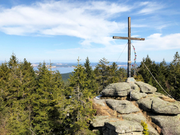
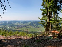
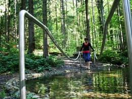
At the start of the route, you will once again climb up to the Šumava ridge. Special views reward you for the effort at Bärenstein, Hochbuchet and Liebesfelsen. Enjoy the excellent Bohemian Forest water at the Michaelsquelle spring or give your feet a break in the Kneipp pool before continuing over the Kalvarienberg to Aigen-Schlägl. A visit to the impressive library in Schlägl Abbey is a memorable end to the hike.You can find the digital route in the Komoot app.
We are also happy to provide you with a detailed description of the stage on request. This is also available for download under Multimedia/Documents.
further information:
- Possible accommodation
- Experience of nature
- Board possible
Details - hiking
- themed path
- Suitable for single travelers
- Suitable for couples
- Spring
- Summer
- Autumn
Please get in touch for more information.
Markt 28
4161 Ulrichsberg
Phone +43 5 7890 - 100
Fax machine +43 5 7890 - 115
E-Mail info@boehmerwald.at
Web www.wegderentschleunigung.at
https://www.wegderentschleunigung.at
You can also visit us on
Visit us on Facebook Visit us on Instagram Visit our videochannel on YouTubeInteractive elevation profile
Create PDF
Tour-Details
Path number: Gelbe Schilder mit Entschleunigungs-Symbol
Starting place: 4161 Ulrichsberg
Destination: 4160 Aigen-Schlägl
duration: 4h 9m
length: 14,3 km
Altitude difference (uphill): 420m
Altitude difference (downhill): 530m
Lowest point: 550m
Highest point: 1.050m
difficulty: medium
condition: medium
panoramic view: Great panorama
Paths covering:
Asphalt, Path / trail, Hiking trail
powered by TOURDATA
