Muehltal Cycle Route R 26


Interactive elevation profile
Create PDF
Tour-Details
Path number: R26
Starting place: 4160 Aigen-Schlägl
Destination: 4131 Obermühl an der Donau
duration: 2h 18m
length: 28,3 km
Altitude difference (uphill): 539m
Altitude difference (downhill): 804m
Lowest point: 305m
Highest point: 683m
difficulty: medium
condition: medium
panoramic view: Some Views
Paths covering:
Asphalt
powered by TOURDATA
Varied cycle path along the small Mühl from Aigen to Obermühl. Fantastic sections through wonderful, untouched nature. Not a circular route! 0 km You start at the Aigen-Schlägl market square. Follow the cycle signposting R26 (Mühltalweg). Cycle towards Schlägl and past Schlägl Abbey. Cross the roundabout in Schlägl straight ahead and cycle to Natschlag. Cycle through the village. You join the B127 in the valley and cross the railway track. Immediately leave the B127 again and continue steeply uphill to Weichsberg. Continue via Kollonödt, Fürling to Rohrbach-Berg railway station.
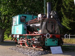
8.8 km The signposted route leads from Rohrbach-Berg railway station to the town centre (you cycle directly past the VILLA sinnenreich museum). At the station, the over 100-year-old locomotive "Aigen" welcomes you and invites you to take a tour through the history of the Mühlkreisbahn.
14.9 km At Stadtplatz (possibility to visit the city exhibition or the beautiful Jakobskirche), turn right before the Trinity Column and follow the road straight ahead. Pass the shopping centre. A short, moderate uphill section to the village of Lanzerstorf follows. From here, the route continues downhill to Obermühl. Past Sprinzenstein to...
17.7 km Hühnergeschrei. At the end of the village, after the fire station, the tour leads right into the Kleine Mühltal valley along the romantic river. Follow the R26 signposts and the "Obermühl" signpost, past the Prechtl sawmill, Schweitzer sawmill and the former paper mill. You have now arrived in...
21.7 km Obermühl. From here, there are two options for continuing your cycle tour: Follow the signs for the Danube cycle path R1. Stay left and cycle through the village. Ferry Obermühl-Kobling (Tel. 07286/7216) - ring the ferry bell when crossing!
Option 1:
Here you cycle along the Danube cycle path on the left bank to Exlau, Untermühl.
37.3 km In Untermühl you have the option of using a longitudinal ferry to "circumnavigate" the missing section of the cycle path by crossing the Untermühl-Kaiserhof-Bremsberg ferry using the call button. If the water level is high, call 07273/6221 to find out whether the ferry is in operation. Then on the R1 towards...
46.5 km Faustschlössl, Landshaag.
50.5 km Continue from Feldkirchen to Ottensheim. Take a cool dip in the Danube in Feldkirchen before tackling the journey to Ottensheim railway station. Return with the Mühlkreisbahn railway.
Option 2:
Cross over by ferry and then continue along the Danube cycle path to Aschach and on to Wilhering. Cross the Untermühl-Kaiserhof ferry using the call button. If the water level is high, call 07273/6221 to find out whether the ferry is in operation.
45 km Aschach (road bridge over the Danube again) or continue to the...
59.7 km Ottensheim power station (crossing the Danube is also possible here).
Just before...
63.0 km Wilhering take the ferry to Ottensheim. Cross the market square, pass the church on the right, then cross the B127 federal road straight ahead and you are at Ottensheim railway station.
64.1 km From Ottensheim railway station, take the Mühlkreisbahn back to the starting point in Aigen-Schlägl. Information at fahrplan.oebb.at
Request a cycle map for EUR 3.00!
With the free outdooractive app, you can follow the route using navigation.
Starting point: Market place Aigen-Schlägl.
Destination: Obermühl with 2 different options to continue to Ottensheim and return to Aigen-Schlägl with the Mühlkreisbahn.
further information:
- Board possible
- Suitable for single travelers
- Suitable for friends
- Suitable for couples
- Spring
- Summer
- Autumn
Please get in touch for more information.
Freistädter Straße 119
4041 Linz
Phone +43 732 221022
Fax machine +43 732 7277 - 701
E-Mail info@oberoesterreich.at
Web www.oberoesterreich.at/landesradweg…
https://www.oberoesterreich.at/landesradwege
")
")
Interactive elevation profile
Create PDF
Tour-Details
Path number: R26
Starting place: 4160 Aigen-Schlägl
Destination: 4131 Obermühl an der Donau
duration: 2h 18m
length: 28,3 km
Altitude difference (uphill): 539m
Altitude difference (downhill): 804m
Lowest point: 305m
Highest point: 683m
difficulty: medium
condition: medium
panoramic view: Some Views
Paths covering:
Asphalt
powered by TOURDATA
