2-Country Family Cycle Route


- Flatly
- Possible accommodation
Interactive elevation profile
Create PDF
Tour-Details
Path number: 808
Starting place: 4155 Nebelberg
Destination: 4155 Nebelberg
duration: 1h 30m
length: 16,2 km
Altitude difference (uphill): 286m
Altitude difference (downhill): 285m
Lowest point: 650m
Highest point: 770m
difficulty: very easy
condition: very easy
panoramic view: Some Views
Paths covering:
Asphalt
powered by TOURDATA
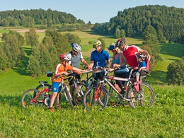
Easy cross-border cycling tour (DE) with light traffic and no steep rises. Ideally suited for families with young children.
0 km Starting point Vordernebelberg (alternative starting point also in Nebelberg, Stift am Grenzbach, or Kohlstatt). You start at the car park at GH Ramlhof, head west and cross the village. The Mühltal cycle route no. 806 also runs parallel to this route. After the end of the village, a narrow, winding tarmac road (garages on the right) leads left into the valley and back up the opposite slope to...
1.4 km Nebelberg. Turn left at the priority road. Immediately leave the main road and follow the signpost on the right to Heinrichsberg and Stift am Grenzbach. The national cycle route R5 now accompanies you, as does the Mühltal cycle route no. 806. You will pass the Heinrichsberg primary school. A short uphill section and you are already at the end of Stift am Grenzbach. Now follows a very scenic section with few climbs through meadows and woodland close to the Bavarian border. A short ascent through the forest begins in the wasteland near the Hellauer farm butcher's shop. Once you reach the top, a wonderful view of the Bohemian Forest opens up before you. You soon reach...
6.0 km Kohlstatt The R5 national cycle path and Mühltal cycle route no. 806 now lead in the other direction. Take the path to the left and cross the border. Immediately afterwards, turn left again, where the signpost points to Messnerschlag. Here you meet the Donau Wald cycle path. The concrete road continues straight ahead downhill through the forest. You pass the...
8.4 km Grenzstüberl Jogl and cycle straight on, soon reaching the scattered settlement of Messnerschlägerwaide. The little-used road leads gently downhill through beautiful meadows and fields. Immediately after a right-hand bend leading downhill, don't overlook the...
11.0 km junction to the left towards Wührhügel. The road leads downhill to Grenzbach
12.0 km You will soon come to a priority road. Turn sharp left here and you are immediately at the former GH Jagawirt. Pass the inn on the left, the sports field is on the right. Climbing slightly, you reach the crossroads (left cross with birch trees on both sides). This completes the circle. Turn right and cycle via Nebelberg back to...
16.2 km Vordernebelberg.
Request our cycle map for EUR 3.00!
Use the free outdooractive app to navigate the route.
Starting point: Ramlhof Inn.
Destination: Ramlhof Inn.
further information:
- Flatly
- Possible accommodation
- Board possible
Most economical season
- Spring
- Summer
- Autumn
Please get in touch for more information.
Nebelberg 50
4155 Nebelberg
Phone +43 5 7890 - 100
Fax machine +43 5 7890 - 115
E-Mail info@boehmerwald.at
Web www.boehmerwald.at/
https://www.boehmerwald.at/
You can also visit us on
Visit us on Facebook Visit us on Instagram Visit our videochannel on YouTube")
Interactive elevation profile
Create PDF
Tour-Details
Path number: 808
Starting place: 4155 Nebelberg
Destination: 4155 Nebelberg
duration: 1h 30m
length: 16,2 km
Altitude difference (uphill): 286m
Altitude difference (downhill): 285m
Lowest point: 650m
Highest point: 770m
difficulty: very easy
condition: very easy
panoramic view: Some Views
Paths covering:
Asphalt
powered by TOURDATA
