Way of St. James Stage 4 Aigen-Schlägl - Rohrbach-Berg


- culturally interesting
- Multi-day tour
- Possible accommodation
Interactive elevation profile
Create PDF
Tour-Details
Starting place: 4160 Aigen-Schlägl
Destination: 4150 Rohrbach-Berg
duration: 4h 30m
length: 15,0 km
Altitude difference (uphill): 540m
Altitude difference (downhill): 478m
Lowest point: 539m
Highest point: 752m
difficulty: medium
condition: medium
panoramic view: Great panorama
Paths covering:
Asphalt, Hiking trail
powered by TOURDATA
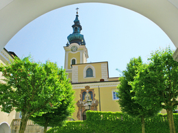
Section of the St. James's Path from Aigen-Schlägl to Rohrbach-Berg.
At Schlägl Abbey turn left into the main road, after approx. 150 m cross the roundabout and immediately after the junction turn right into Schachlingstraße.
Now approx. 1 km uphill on the asphalt road through the Schachling settlement.
At the end of the settlement you come to an asphalt crossroads, turn right and after approx. 100 m immediately left again into the forest path. Now continue uphill first on the forest path and then on the meadow path to St. Wolfgang, 738 m. (pilgrimage church and peace chapel).
Now walk approx. 900 m on the tarmac road towards Schlägl and turn right at the wayside shrine onto the forest path, continuing through Geiselreith, 640 m, you come to the Schlägl circular path and continue parallel to it.
Cross the Mühlkreisbahn railway tracks in the valley, 550 m, and uphill along the main road. You
come to Katzing, 580m, one of the most beautiful villages built of stone block walls.
Continue on the field path until shortly before Kollonödt, turn-off to Rohrbach. (approx. 200m uphill to the Kollonödt inn, 620m). From the valley crossing parallel to the Kirsteig uphill into the forest, forest path up to the heights, keep left there on the heights until above the village of Fürling, the path leaves the forest, now a short stretch downhill on the road, turn left at the bus stop, through between the houses, a stretch on a meadow path, then turn right onto the road, approx. 800m, then turn left between the building yard and dairy onto the meadow path on the left, which shortly afterwards turns into a forest path. 2 options are available at the following crossroads at the edge of the forest:
Option 1, via GH-Mosthütte: stay straight ahead on the field path, cross the railway line uphill and immediately follow the road to the left, through the forest to the Mosthütte snack station. From here, head uphill on the old pilgrimage path to the Maria Trost pilgrimage church and downhill to the Rohrbach-Berg parish church.
Variant 2, directly to Rohrbach-Berg: turn right uphill in the opposite direction to the Psalmenweg
, cross the railway line and follow a beautiful meadow path to the hill, magnificent
view. Past the Liberation Cross to the road, from here downhill on the chapel path and
follow the markings to the parish church in Rohrbach-Berg.
Stamping point for the Way of St James stamp: Gasthof Dorfner, Stadtplatz 25, Rohrbach-Berg
Further stages of this Way of St. James route.
Request our hiking map for EUR 3.00!
With the free app outdooractive you can hike the route by navigation.
Starting point: For this stage: Schlägl Abbey.
Destination: The finishing point of this stage is Rohrbach-Berg.
further information:
- Multi-day tour
- Possible accommodation
- Board possible
Details - hiking
- themed path
")
")
")
Most economical season
- Spring
- Summer
- Autumn
Please get in touch for more information.
Hauptstraße 2
4160 Aigen-Schlägl
Phone +43 5 7890 - 100
Fax machine +43 5 7890 - 115
E-Mail info@boehmerwald.at
Web www.boehmerwald.at/
https://www.boehmerwald.at/
You can also visit us on
Visit us on Facebook Visit us on Instagram Visit our videochannel on YouTube")
")
")
Interactive elevation profile
Create PDF
Tour-Details
Starting place: 4160 Aigen-Schlägl
Destination: 4150 Rohrbach-Berg
duration: 4h 30m
length: 15,0 km
Altitude difference (uphill): 540m
Altitude difference (downhill): 478m
Lowest point: 539m
Highest point: 752m
difficulty: medium
condition: medium
panoramic view: Great panorama
Paths covering:
Asphalt, Hiking trail
powered by TOURDATA
