Mühlviertel Bike Path R5


- culinary interesting
- culturally interesting
- Multi-day tour
- Possible accommodation
Interactive elevation profile
Create PDF
Tour-Details
Path number: R5
Starting place: 4143 Neustift im Mühlkreis
Destination: 4360 Grein
duration: 19h 25m
length: 239,0 km
Altitude difference (uphill): 4.484m
Altitude difference (downhill): 4.548m
Lowest point: 237m
Highest point: 993m
difficulty: medium
condition: medium
panoramic view: Some Views
Paths covering:
Asphalt, Gravel
powered by TOURDATA
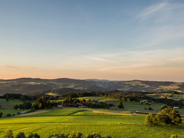
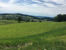
By taking the Mühlviertel Bike Path, you will be immediately immersed in the mysterious and mystic granite landscape north of the Danube. The bike path offers athletic bikers one challenging incline after another. At its starting point in Kramesau, it is connected to the Danube Bike Path, and you will have to really pump those pedals right on the first leg to Neustift, since you will be leaving the lowlands of the Danube Valley and entering the highlands of the Mühlviertel. In the Bohemian Forest, you will finally reach the border to the Czech Republic. Aigen-Schlägl, with its grand Premonstratensian Canonical Monastery, and Schwarzenberg, with its park for wooden sculptures, are your next stations on the way to Haslach, which is known as a textile market. A special museum provides information about the long tradition of linen weaving. You will continue on towards the east and arrive in Bad Leonfelden, where the moor and the teachings of Father Kneipp generate positive health effects. At the Schulmuseum (School Museum) and Schwedenschanze (Swedish Redoubt), you can also let the spirit of the past take its effect on you. You should also stop off in Windhaag near Freistadt. This is the village where composer Anton Bruckner, who would later become famous, worked as a teacher, and the Brucknerstüberl in the Old Schoolhouse reminds visitors of this fact. The town of Sandl is also located along the Mühlviertel Bike Path and is a hub for rural reverse-glass painting. At the Hinterglasmuseum (Reverse-Glass Museum), you can discover the secrets of this form of art. After passing Rosenhof Palace, with its picturesque ponds, you will arrive in Liebenau. A few kilometres later, you will have the opportunity to turn east in order to continue further into the Waldviertel. The Mühlviertel Bike Path itself now turns towards the south and leads along the border to Lower Austria to the romantic little Danube city of Grein, with its lovely Greinburg Palace and city theatre rich in curios. At this point, there is also a junction with the Danube Bike Path.
Route number: R5
Route number: R5
Starting point: Mühlviertel Bike Path in Kramesau
Destination: Danube Bike Path in Grein
further information:
- culinary interesting
- Multi-day tour
- Possible accommodation
- Board possible
")

")
")
")
")
")
")
")
")
")

")
")
")
")
")
")
")
")
")
")
")
")
")
")
")
")
")
")
")
")
")
")


")

")


")
")
")

")
Accessibility / arrival
Travelling by car:
Linz or Wels - Eferding or Aschach - towards Passau - Donaubrücke Niederranna - Neustift i.M
Coming from Germany:
Motorway exit Passau/Nord - Obernzell - Untergriesbach - (border crossing) Neustift ob der Donau.
Nearest railway station in Austria:
Rohrbach (Mühlkreisbahn)
or Linz (central railway junction)
Nearest railway station in Germany:
Passau
Travelling by ship:
possible at the shipping piers in Linz or Passau (Germany)
Possibilities for getting on or off between Obernzell (Germany) and Schlögen (Austria) (Wurm & Köck shipping company)
The starting point is located south of the municipality in Kramesau.
Most economical season
- Spring
- Summer
- Autumn
Please get in touch for more information.
4160 Aigen-Schlägl
Phone +43 5 7890 - 100
E-Mail info@muehlviertel.at
Web www.muehlviertel.at
https://www.muehlviertel.at
You can also visit us on
Visit us on Facebook Visit us on Instagram Visit our videochannel on YouTube")
")
")
")
")
")
")

")
")
")
")
")
")
")
")
Interactive elevation profile
Create PDF
Tour-Details
Path number: R5
Starting place: 4143 Neustift im Mühlkreis
Destination: 4360 Grein
duration: 19h 25m
length: 239,0 km
Altitude difference (uphill): 4.484m
Altitude difference (downhill): 4.548m
Lowest point: 237m
Highest point: 993m
difficulty: medium
condition: medium
panoramic view: Some Views
Paths covering:
Asphalt, Gravel
powered by TOURDATA
