 Mühlviertel Marken GmbH, Hochhauser.")
 Mühlviertel Marken GmbH, Hochhauser.")
Hop Cycle Route


- Flatly
- Possible accommodation
Interactive elevation profile
Create PDF
Tour-Details
Path number: 809
Starting place: 4170 Haslach an der Mühl
Destination: 4170 Haslach an der Mühl
duration: 1h 39m
length: 20,4 km
Altitude difference (uphill): 376m
Altitude difference (downhill): 382m
Lowest point: 485m
Highest point: 652m
difficulty: medium
condition: medium
panoramic view: Dreamtour
Paths covering:
Asphalt, Other
powered by TOURDATA
Beautiful cycling trail along the green fields of the Bohemian Forest vacation area.
0 km The start is in Neudorf at the former GH Diendorfer. Cycle in a southerly direction until you reach the Unterkagerer junction 360 m and turn right onto the Hehenberg goods road. Immediately afterwards, don't take the turn-off to Unterkagerer but continue straight on and uphill through a short section of forest.
Rural cultural heritage at the Unterkagerer monument farm: four-sided farmhouse with a 17th century residential wing, Stable building from around 1800.
The tour leads downhill to...
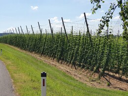
1.6 km Auberg. Here you turn right at the crossroads into the Auberg goods road. You now cycle downhill past hop fields to the...
3.8 km valley of the Große Mühl river. You turn left. The cycle path is flat and continues straight ahead along the river.
6.5 km At the crossroads, do not go to St.Peter/Auberg but straight ahead into the Bachmühle goods road, following the signpost for Rohrbach/Arnreit and always following cycle signpost no. 809.
6.8 km You will soon come to the bridge over the Große Mühl. Here, however, you continue straight ahead onto the Iglbach goods road. The road now leaves the course of the river. Now cycle uphill to...
8.0 km Iglbach. At the next fork in the road, turn right towards the quarry. On the hill in front of you, you will see the small church of St Anna in Steinbruch. This church was built between 1509 and 1514. Around 1700, the church was given a splendid baroque interior. Today, the church is the venue for numerous concerts.
The road continues uphill to the...
9.6 km junction. Continue left here, unless you take the short detour to the church. From now on, cycle straight ahead, partly downhill. You can already see the church tower of St Peter's in the distance. You pass the hop fields and immediately afterwards turn left onto the...
11.5 km priority road towards Haslach. Shortly afterwards you will reach...
12.7 km St. Peter am Wimberg. Do not go uphill to the church but turn left towards Arnreit into Aubergstraße. You will pass the sports facilities and the building yard and cycle downhill along the Wimmer goods road into the valley (fish pond on the right). The cycle path leads uphill over the bridge, you will see hop fields to the left and right.
14.4 km At the next turn-off don't turn into the Hopfenau and Knoglmühle estate roads but continue straight ahead. At the next junction, continue straight over the crest and not into the Grünhäusl estate road.
15.8 km Follow the curve right, not into the Mairhofer estate road, and continue downhill to Hollerberg. Then uphill again.
16.1 km After the Auberg municipal office, turn right towards Hollerberg onto the goods road of the same name. Continue straight ahead and don't turn into the Marbach farm track until the next...
17.0 km crossroads (Marterl, bench). Continue left here towards Maria Rast. The tour leads steeply downhill. In the...
17.8 km valley hollow, turn right before the small bridge and cycle steeply uphill to the farm and past the hop field. Shortly afterwards, take the left branch and you will soon reach the...
19.2 km junction with the priority road. Continue left here at the Kasten bus stop.
19.5 km A detour to the school museum in Kasten is worthwhile.
Experience three rooms in a school atmosphere from 1900!
Now continue straight on towards Haslach. The loop closes at the Unterkagerer junction and it is only a few metres to the...
21 km starting point Neudorf.
Request our cycle map for EUR 3.00!
With the free outdooractive app, you can follow the route by navigation.
0 km The start is in Neudorf at the former GH Diendorfer. Cycle in a southerly direction until you reach the Unterkagerer junction 360 m and turn right onto the Hehenberg goods road. Immediately afterwards, don't take the turn-off to Unterkagerer but continue straight on and uphill through a short section of forest.
Rural cultural heritage at the Unterkagerer monument farm: four-sided farmhouse with a 17th century residential wing, Stable building from around 1800.
The tour leads downhill to...
1.6 km Auberg. Here you turn right at the crossroads into the Auberg goods road. You now cycle downhill past hop fields to the...
3.8 km valley of the Große Mühl river. You turn left. The cycle path is flat and continues straight ahead along the river.
6.5 km At the crossroads, do not go to St.Peter/Auberg but straight ahead into the Bachmühle goods road, following the signpost for Rohrbach/Arnreit and always following cycle signpost no. 809.
6.8 km You will soon come to the bridge over the Große Mühl. Here, however, you continue straight ahead onto the Iglbach goods road. The road now leaves the course of the river. Now cycle uphill to...
8.0 km Iglbach. At the next fork in the road, turn right towards the quarry. On the hill in front of you, you will see the small church of St Anna in Steinbruch. This church was built between 1509 and 1514. Around 1700, the church was given a splendid baroque interior. Today, the church is the venue for numerous concerts.
The road continues uphill to the...
9.6 km junction. Continue left here, unless you take the short detour to the church. From now on, cycle straight ahead, partly downhill. You can already see the church tower of St Peter's in the distance. You pass the hop fields and immediately afterwards turn left onto the...
11.5 km priority road towards Haslach. Shortly afterwards you will reach...
12.7 km St. Peter am Wimberg. Do not go uphill to the church but turn left towards Arnreit into Aubergstraße. You will pass the sports facilities and the building yard and cycle downhill along the Wimmer goods road into the valley (fish pond on the right). The cycle path leads uphill over the bridge, you will see hop fields to the left and right.
14.4 km At the next turn-off don't turn into the Hopfenau and Knoglmühle estate roads but continue straight ahead. At the next junction, continue straight over the crest and not into the Grünhäusl estate road.
15.8 km Follow the curve right, not into the Mairhofer estate road, and continue downhill to Hollerberg. Then uphill again.
16.1 km After the Auberg municipal office, turn right towards Hollerberg onto the goods road of the same name. Continue straight ahead and don't turn into the Marbach farm track until the next...
17.0 km crossroads (Marterl, bench). Continue left here towards Maria Rast. The tour leads steeply downhill. In the...
17.8 km valley hollow, turn right before the small bridge and cycle steeply uphill to the farm and past the hop field. Shortly afterwards, take the left branch and you will soon reach the...
19.2 km junction with the priority road. Continue left here at the Kasten bus stop.
19.5 km A detour to the school museum in Kasten is worthwhile.
Experience three rooms in a school atmosphere from 1900!
Now continue straight on towards Haslach. The loop closes at the Unterkagerer junction and it is only a few metres to the...
21 km starting point Neudorf.
Request our cycle map for EUR 3.00!
With the free outdooractive app, you can follow the route by navigation.
Starting point: Neudorf.
Destination: Neudorf.
further information:
- Flatly
- Possible accommodation
- Board possible
Most economical season
- Spring
- Summer
- Autumn
Please get in touch for more information.
Stahlmühle 4
4170 Haslach an der Mühl
Phone +43 5 7890 - 100
Fax machine +43 5 7890 - 115
E-Mail info@boehmerwald.at
Web www.boehmerwald.at/
https://www.boehmerwald.at/
You can also visit us on
Visit us on Facebook Visit us on Instagram Visit our videochannel on YouTubeInteractive elevation profile
Create PDF
Tour-Details
Path number: 809
Starting place: 4170 Haslach an der Mühl
Destination: 4170 Haslach an der Mühl
duration: 1h 39m
length: 20,4 km
Altitude difference (uphill): 376m
Altitude difference (downhill): 382m
Lowest point: 485m
Highest point: 652m
difficulty: medium
condition: medium
panoramic view: Dreamtour
Paths covering:
Asphalt, Other
powered by TOURDATA
