Wittinghausen cycle route


- culturally interesting
- Flatly
- Possible accommodation
Interactive elevation profile
Create PDF
Tour-Details
Path number: 805
Starting place: 4170 Haslach an der Mühl
Destination: 4170 Haslach an der Mühl
duration: 4h 0m
length: 30,2 km
Altitude difference (uphill): 570m
Altitude difference (downhill): 550m
Lowest point: 501m
Highest point: 992m
difficulty: difficult
condition: difficult
panoramic view: Great panorama
Paths covering:
Asphalt, Gravel
powered by TOURDATA
roadblock: Akutmeldung/Sperre
Beautiful cross-border cycling trail with wonderful views of the Bohemian Forest vacation area and the Czech Republic.
0 km Starting point in the market square of Haslach an der Mühl. Take Windgasse through the defence tower and follow the road downhill. Cross the main road and follow the mountain road, keeping left at the fork in the road. Continue straight ahead and turn left at...
1.6 km Jaukerberg. After approx. 600 metres, turn right onto Bärenholzstraße, which first leads you onto asphalt and then through a short section of forest. Continue along the dirt track, which ends at a farm and turn left onto the road downhill, which takes you to...
4.4 km Unterurasch. Turn left here, cross the bridge and follow the road. Turn right at the crossroads and follow the road uphill to...
6.8 km to St. Oswald bei Haslach. Follow the signs uphill and you will reach the...
8.2 km border crossing. Follow the forest path and you will reach Koranda/Rosenhügel. Go straight downhill towards Frydava. Don't miss the turn-off to the right at Janova Cesta towards Sv. Tomas! From here, follow cycle path no. 1033 uphill through the forest and you will reach...
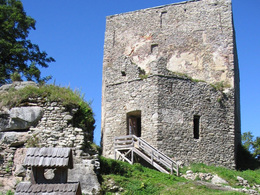
18 km to Sv. Tomas. Here it is worth making a short detour to the Wittinghausen ruins with a wonderful view over the Vltava reservoir. From here, the tour continues downhill on cycle path no. 1033. At the crossroads, keep right, uphill for a short distance and then downhill again to...
22.6 km to Pasecna. Cross the small village and continue straight ahead at the crossroads, past the collective farm and the road will take you to...
25.1 km Hörleinsödt border. The tour now runs downhill to Hörleinsödt and continues along the road back to your...
30.2 km starting point Haslach an der Mühl.
Request our cycle map for EUR 3.00!
Use the free outdooractive app to navigate the route.
0 km Starting point in the market square of Haslach an der Mühl. Take Windgasse through the defence tower and follow the road downhill. Cross the main road and follow the mountain road, keeping left at the fork in the road. Continue straight ahead and turn left at...
1.6 km Jaukerberg. After approx. 600 metres, turn right onto Bärenholzstraße, which first leads you onto asphalt and then through a short section of forest. Continue along the dirt track, which ends at a farm and turn left onto the road downhill, which takes you to...
4.4 km Unterurasch. Turn left here, cross the bridge and follow the road. Turn right at the crossroads and follow the road uphill to...
6.8 km to St. Oswald bei Haslach. Follow the signs uphill and you will reach the...
8.2 km border crossing. Follow the forest path and you will reach Koranda/Rosenhügel. Go straight downhill towards Frydava. Don't miss the turn-off to the right at Janova Cesta towards Sv. Tomas! From here, follow cycle path no. 1033 uphill through the forest and you will reach...
18 km to Sv. Tomas. Here it is worth making a short detour to the Wittinghausen ruins with a wonderful view over the Vltava reservoir. From here, the tour continues downhill on cycle path no. 1033. At the crossroads, keep right, uphill for a short distance and then downhill again to...
22.6 km to Pasecna. Cross the small village and continue straight ahead at the crossroads, past the collective farm and the road will take you to...
25.1 km Hörleinsödt border. The tour now runs downhill to Hörleinsödt and continues along the road back to your...
30.2 km starting point Haslach an der Mühl.
Request our cycle map for EUR 3.00!
Use the free outdooractive app to navigate the route.
Starting point: Market place Haslach an der Mühl.
Destination: Market place Haslach an der Mühl.
further information:
- Flatly
- Possible accommodation
- Board possible
Most economical season
- Spring
- Summer
- Autumn
Please get in touch for more information.
Stahlmühle 4
4170 Haslach an der Mühl
Phone +43 5 7890 - 100
Fax machine +43 5 7890 - 115
E-Mail info@boehmerwald.at
Web www.boehmerwald.at
https://www.boehmerwald.at
You can also visit us on
Visit us on Facebook Visit us on Instagram Visit our videochannel on YouTube")
")

Interactive elevation profile
Create PDF
Tour-Details
Path number: 805
Starting place: 4170 Haslach an der Mühl
Destination: 4170 Haslach an der Mühl
duration: 4h 0m
length: 30,2 km
Altitude difference (uphill): 570m
Altitude difference (downhill): 550m
Lowest point: 501m
Highest point: 992m
difficulty: difficult
condition: difficult
panoramic view: Great panorama
Paths covering:
Asphalt, Gravel
powered by TOURDATA
