Three-country view path


- Flatly
Interactive elevation profile
Create PDF
Tour-Details
Path number: 39
Starting place: 4153 Peilstein im Mühlviertel
Destination: 4153 Peilstein im Mühlviertel
duration: 1h 30m
length: 4,3 km
Altitude difference (uphill): 193m
Altitude difference (downhill): 191m
Lowest point: 795m
Highest point: 872m
difficulty: easy
condition: easy
panoramic view: Dreamtour
Paths covering:
Asphalt, Hiking trail
powered by TOURDATA
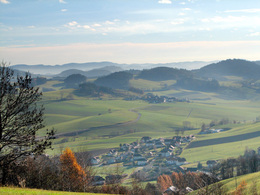
Beautiful hiking trail with mesmerising views of the Bohemian Forest vacation area.
0 km From Eschernhof walk in a northerly direction briefly uphill to the ridge and then downhill to the ...
250 m Hemmerau dry biotope and the Hochwaldblick. From there, there is a wonderful view of the Mühltal ridge with its villages. Behind Adalbert Stifter's Hochwald, from Wittinghausen to Plöckenstein and the "Atlantis of the Bohemian Forest", the former Sudetenland, whose villages were levelled between 1945 and 1950 and the settlers there were expelled. You hike briefly downhill, then the path continues flat to the ...
0.6 km Eschernhofer-Leitenhäusern. Now continue left, approx. 200 m slightly uphill and downhill again to the ...
1 km of road, where you turn left for the small loop (0.5 hours | 1.1 km) and take the shortcut to Eschernhof .
If you have opted for the long loop via Lengau, continue right along the
road. After about 100 metres, turn left onto the field path. You walk briefly through the forest, past a small chapel (Wolfskapelle). Climbing slightly, you reach the ...
2.3 km village of Lengau with a beautiful chapel dedicated to the Virgin Mary. Here uphill towards the forest. Bench with a beautiful view. It's worth lingering there. Enjoy the view to where the Bavarian Forest and the Bohemian Forest meet. The trail continues through the forest. You will pass the wolf pit (the wolf trap probably dates back to the Middle Ages). Shortly afterwards, you can make a detour (not included in the total time) to the Hochstein (findings indicate that a wooden clearing castle of the Falkensteiner family probably stood on the Hochstein). Continue following the signs. Beautiful views await you. Do not overlook ...
3.4 km the turn-off to the left (Stoanaweg continues straight ahead). The hiking trail leads uphill into the forest. After about 300 metres, you will see Printer Franzl Stein on the bottom right. The printer Franzl, who lived around 1700, was a well-known smuggler and robber who hid there from his pursuers and printed himself before being punished, hence the name. You continue the hike along the signposted hiking trail, with colour markings on the trees, and soon reach the...
4.3 km starting point Eschernhof.
Request our hiking map for EUR 3.00!
With the free outdooractive app, you can hike the trail using navigation.
Starting point: Eschernhof near Peilstein.
Destination: Eschernhof near Peilstein.
further information:
- Flatly
- Board possible
Most economical season
- Spring
- Summer
- Autumn
Please get in touch for more information.
Markt 7
4153 Peilstein im Mühlviertel
Phone +43 5 7890 - 100
Fax machine +43 5 7890 - 115
E-Mail info@boehmerwald.at
Web www.boehmerwald.at
https://www.boehmerwald.at
You can also visit us on
Visit us on Facebook Visit us on Instagram Visit our videochannel on YouTube")
")
")
Interactive elevation profile
Create PDF
Tour-Details
Path number: 39
Starting place: 4153 Peilstein im Mühlviertel
Destination: 4153 Peilstein im Mühlviertel
duration: 1h 30m
length: 4,3 km
Altitude difference (uphill): 193m
Altitude difference (downhill): 191m
Lowest point: 795m
Highest point: 872m
difficulty: easy
condition: easy
panoramic view: Dreamtour
Paths covering:
Asphalt, Hiking trail
powered by TOURDATA
