Grenzbachrunde


- Flatly
Interactive elevation profile
Create PDF
Tour-Details
Path number: 12
Starting place: 4154 Kollerschlag
Destination: 4154 Kollerschlag
duration: 3h 0m
length: 11,0 km
Altitude difference (uphill): 255m
Altitude difference (downhill): 252m
Lowest point: 618m
Highest point: 764m
difficulty: medium
condition: medium
panoramic view: Some Views
Paths covering:
Asphalt, Hiking trail
powered by TOURDATA
Beautiful hike through the Bohemian Forest alongside the Austrian/Bavarian border.
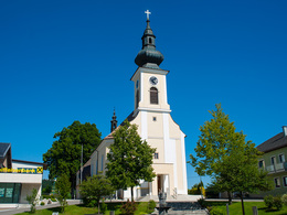
0 km The starting point of the hike is the Kollerschlag market square. You walk along the pavement in the direction of Sarleinsbach. After 200 metres, leave the road and walk slightly uphill along the Ameisbergweg through the settlement. Before the wayside shrine, a field path leads right to...
2.4 km Mistlberg. 500 m after the village, leave the tarmac road and turn right onto the field path, which turns into a beautiful forest path. You will pass the
3.6 km former Haselbach customs house. The path now runs parallel to the Danube-Ameisberg circular route. Turn off from the short tarmac section towards the forest. A bench here offers marvellous views of Mistlberg and Bavaria. On a deeply cut hollow path with mosses and ferns, the trail descends slightly to the junction with the tarmac road. Past the...
4.5 km sawmill (formerly Tempelmühle), the trail now leads 2 km on the little-used asphalt road parallel to the Osterbach and the state border to the...
6.6 km Wegscheid border crossing. You cross the road. To the right, a beautiful path leads briefly through the forest into the open. You walk along the edge of the forest; a wonderful view over meadows and fields opens up in front of you on the right. After a few hundred metres, you will come to the...
7.6 km rest area at the customs hut (warden's hut). Several of these wooden huts used to stand along the border. They were built as shelters for the border guards who patrolled on foot and needed a place to warm up, especially in bad weather. The customs huts were erected at points where the customs officers had a wide view of the border section. Now a flat path leads through the forest and you reach the...
8.9 km Kasernhäusl. Here you take the turn-off Weg der Entschleunigung to Julbach. Follow the field path to the right, ascending back to...
11.0 km Kollerschlag.
Just before you reach the hill, take a look back. To the west, the view falls towards Bavaria, to the north you can see the Bohemian Forest in the background and looking east, you can enjoy the view of the hilly Mühlviertel.
Request our hiking map for EUR 3.00!
With the free outdooractive app, you can hike the trail using navigation.
Most economical season
- Spring
- Summer
- Autumn
Please get in touch for more information.
Markt 14
4154 Kollerschlag
Phone +43 5 7890 - 100
Fax machine +43 5 7890 - 115
E-Mail info@boehmerwald.at
Web www.boehmerwald.at/
https://www.boehmerwald.at/
You can also visit us on
Visit us on Facebook Visit us on Instagram Visit our videochannel on YouTubeInteractive elevation profile
Create PDF
Tour-Details
Path number: 12
Starting place: 4154 Kollerschlag
Destination: 4154 Kollerschlag
duration: 3h 0m
length: 11,0 km
Altitude difference (uphill): 255m
Altitude difference (downhill): 252m
Lowest point: 618m
Highest point: 764m
difficulty: medium
condition: medium
panoramic view: Some Views
Paths covering:
Asphalt, Hiking trail
powered by TOURDATA


