Guckerweg


- Flatly
- Possible accommodation
Interactive elevation profile
Create PDF
Tour-Details
Path number: 7
Starting place: 4162 Julbach
Destination: 4162 Julbach
duration: 3h 30m
length: 12,8 km
Altitude difference (uphill): 376m
Altitude difference (downhill): 376m
Lowest point: 520m
Highest point: 746m
difficulty: medium
condition: medium
panoramic view: Dreamtour
Paths covering:
Asphalt, Gravel, Hiking trail
powered by TOURDATA
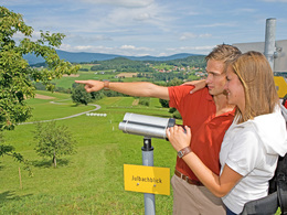
Wonderful hike through the Bohemian Forest vacation area with lots of telescopes alongside the trail.
0 km You start the hike in Julbach. Walk past the church on the right and down into the Kleine Mühl valley. Cross the river and continue uphill on a meadow and forest path. A short tarmac section leads you to the so-called "Leithen", where there is a rest area and the "Julbachblick" lookout point. Turn left and you will reach the highest point of the hike (736 m) via the village of Leithen and have a wonderful view over the Mühlviertel hills and the Bohemian Forest from the ...
3.3 km peeper station "Böhmerwaldblick mit Skigebiet Hochficht" . After 400 m you come to the "Heinrichsberg scattered settlement" lookout station. The route continues, mostly flat, on field paths and a short asphalt section in between to ...
5.5 km Vorderschiffl (723 m). Stay on the road for a short while and then turn left onto the meadow path, which takes you to ...
6.8 km Schopper (722 m). Turn left onto the road. Shortly after leaving the road, turn left onto the dirt track. The path now runs downhill to Emsmannsreith. Before Emsmannsreith, you will find the "Blick auf Zwischenmühlrücken" (view of Zwischenmühlrücken) peeper station
Continue downhill, past the Lindorfer farm with its magnificent view (Zwei Gemeinden-Blick peeper station) and after a further 300 metres at the "Blick ins Tal der Kleinen Mühl" peeper station, continue to...
9.5 km Niederkraml (563 m) - an alternative starting point for this hike. From here, the hike runs parallel to the Weiselweg trail. Shortly after the end of Niederkraml, turn right onto the Wiesenweg (Guckerstation "Julbachblick"). You will soon cross the Kleine Mühl. The path then leads uphill back to ...
12.8 km Starting point Julbach.
Request our hiking map for EUR 3.00!
With the free outdooractive app, you can hike the trail using navigation.
Starting point: Julbach town square.
Destination: Julbach town square.
further information:
- Flatly
- Possible accommodation
- Board possible
Details - hiking
- themed path
Most economical season
- Spring
- Summer
- Autumn
Please get in touch for more information.
Schulstraße 4
4162 Julbach
Phone +43 5 7890 - 100
Fax machine +43 5 7890 - 115
E-Mail info@boehmerwald.at
Web www.boehmerwald.at/
https://www.boehmerwald.at/
You can also visit us on
Visit us on Facebook Visit us on Instagram Visit our videochannel on YouTube")
")

")
Interactive elevation profile
Create PDF
Tour-Details
Path number: 7
Starting place: 4162 Julbach
Destination: 4162 Julbach
duration: 3h 30m
length: 12,8 km
Altitude difference (uphill): 376m
Altitude difference (downhill): 376m
Lowest point: 520m
Highest point: 746m
difficulty: medium
condition: medium
panoramic view: Dreamtour
Paths covering:
Asphalt, Gravel, Hiking trail
powered by TOURDATA
