Haslach circular route


- Suitable for pushchairs
- Flatly
- Possible accommodation
Interactive elevation profile
Create PDF
Tour-Details
Paths covering:
Markings: yellow aluminium signs, also red-white-red colour markings on trees.
0 km You start the hike at Marktplatz Haslach, walk along Sternwaldstraße to Marktstube, turn right and continue via Rebenleiten to ...
1.4 km ... Welset Pühret. This is a true paradise for those seeking relaxation. The benches and adjacent playground invite you to take a break. Cross the bridge and continue right along the Steinerne Mühl to Linzer Straße on the pavement to the former ...
1.9 km ... Rechberger Fabrik and turn left there, past the Notarquelle, to the ...
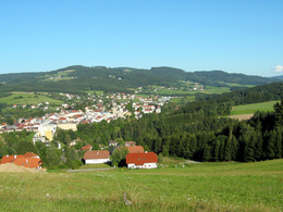
2.6 km ... Stegmühle. From there, you have a particularly beautiful view of Haslach parish church and the ring wall with the Färber-Maier tower. As you can see, Haslach stands on a hill. Haslach's parish church of St Nicholas is the most impressive late Gothic church in the Upper Mühlviertel. Its older part is the presbytery with ribbed vaulting dating from around 1350. The tower, which now stands free and was built as a defence tower for the market fortifications, is Haslach's landmark. Continue along the Steinerne Mühl and then over the bridge to the ...
3.0 km ... Steel mill. Linseed oil has been pressed in the Mühlviertel oil mill for more than 500 years. The mill was first mentioned in a document in 1497, in the will of Sigmund Vorauer, who bequeathed the "Saltenmühle, eine Mühle mit Ölgang" to the Haslach bakers' guild. (Visits are possible by appointment).
The Manufaktur Haslach, which is located right next door, can also be visited by appointment. Step by step, you can see the various work stages from the raw wool to the final product. From there, you have a very good view of the imposing building of the former Vonwiller weaving mill, where the Museum Mechanische Klangfabrik and the Textile Centre Haslach with the Weaving Museum can be visited. You can also see the largest iron 12 metres long (the mangle) in its own glass house in the garden with dyer's plants. Continue past the power station, along the Große Mühl - Lanitz and then right up to the pavement. Walk down the pavement to the main road, cross it and walk 200 metres up Bergstraße and then turn right again just after the Lauss company. Walk along the path parallel to the main road to the junction, cross it and walk along the Marktbach stream ...
4.9 km ... back to the starting point at Marktplatz Haslach an der Mühl.
Request our hiking map for EUR 3.00!
With the free outdooractive app, you can hike the trail using navigation.
further information:
- Flatly
- Possible accommodation
- Board possible
- Suitable for pushchairs
- Spring
- Summer
- Autumn
Please get in touch for more information.
Stahlmühle 4
4170 Haslach an der Mühl
Phone +43 5 7890 - 100
Fax machine +43 5 7890 - 115
E-Mail info@boehmerwald.at
Web www.boehmerwald.at/
You can also visit us on
Visit us on Facebook Visit us on Instagram Visit our videochannel on YouTube")
")
")
")
")
")

")
Interactive elevation profile
Create PDF
Tour-Details
Paths covering:
