Schlägler circular route


- Flatly
- Possible accommodation
Interactive elevation profile
Create PDF
Tour-Details
Path number: 45
Starting place: 4160 Aigen-Schlägl
Destination: 4160 Aigen-Schlägl
duration: 2h 42m
length: 9,1 km
Altitude difference (uphill): 234m
Altitude difference (downhill): 232m
Lowest point: 531m
Highest point: 662m
difficulty: medium
condition: medium
panoramic view: Great panorama
Paths covering:
Asphalt, Hiking trail, Other
powered by TOURDATA
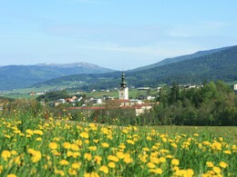
The highlights along this hiking trail are the magnificent views into the valley of the Große Mühl with the Bohemian Forest in the background and the beautiful villages of Geiselreith and Katzing (stone castle masonry).
Markings: yellow aluminium signs, also red-white-red colour markings on trees
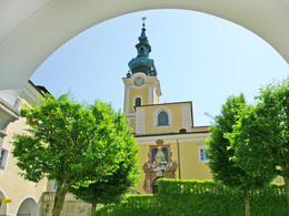
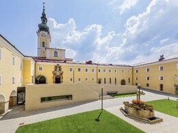
0 km The hike begins at Schlägl Abbey (544 metres altitude difference). Cross the roundabout in the direction of the Jauker petrol station
Follow the asphalt road in the direction of Natschlag. At the crossroads, take the path to the left and then immediately right again and walk uphill for approx. 200 metres on asphalt, then join the meadow path, past the Winterschwer shooting club, a short stretch through the forest and continue on the ...
1.8 km ... field path to Geiselreith (640 m). The clearing and reclamation of the region only began with the founding of Schlägl Abbey in 1218. The villages with the syllable endings -reit, -schlag and -brand indicate the way in which the land was cleared.
The forest was cut down, the areas cleared by fire, cleared. Those with the syllables -ing and -heim are the oldest settlements (Katzing, Rudolfing).
In Geiselreith you continue along the marked path, cross the tracks of the Mühlkreisbahn railway in the valley (550 m) and the main road uphill.
3.6 km You will see Katzing (580 m), one of the most beautiful villages built of stone block walls. A lack of building lime made it necessary to plaster the walls sparingly, as a complete plastering of the façade would have been too expensive. Continue along the dirt track to ...
4.8 km ... Kollonödt (620 m). At the inn, turn left onto the tarmac road and follow it for a short distance until signpost no. 45 points right onto the forest path. Past the quarry to ...
6.0 km ... Winkl (580 m), continue left. At the chapel, turn right onto the field path. The forest path now leads downhill past the Bruckhäusln. At the Bruckhäusln, turn right onto the dirt track and then left. You walk slightly uphill between the ponds, follow the field path straight ahead, cross the tracks of the Mühlkreisbahn railway and continue along the road ...
9.1 km ... return to the starting point at Schlaegl Abbey.
Request our hiking map for EUR 3.00!
With the free outdooractive app, you can hike the trail using navigation.
Markings: yellow aluminium signs, also red-white-red colour markings on trees
0 km The hike begins at Schlägl Abbey (544 metres altitude difference). Cross the roundabout in the direction of the Jauker petrol station
Follow the asphalt road in the direction of Natschlag. At the crossroads, take the path to the left and then immediately right again and walk uphill for approx. 200 metres on asphalt, then join the meadow path, past the Winterschwer shooting club, a short stretch through the forest and continue on the ...
1.8 km ... field path to Geiselreith (640 m). The clearing and reclamation of the region only began with the founding of Schlägl Abbey in 1218. The villages with the syllable endings -reit, -schlag and -brand indicate the way in which the land was cleared.
The forest was cut down, the areas cleared by fire, cleared. Those with the syllables -ing and -heim are the oldest settlements (Katzing, Rudolfing).
In Geiselreith you continue along the marked path, cross the tracks of the Mühlkreisbahn railway in the valley (550 m) and the main road uphill.
3.6 km You will see Katzing (580 m), one of the most beautiful villages built of stone block walls. A lack of building lime made it necessary to plaster the walls sparingly, as a complete plastering of the façade would have been too expensive. Continue along the dirt track to ...
4.8 km ... Kollonödt (620 m). At the inn, turn left onto the tarmac road and follow it for a short distance until signpost no. 45 points right onto the forest path. Past the quarry to ...
6.0 km ... Winkl (580 m), continue left. At the chapel, turn right onto the field path. The forest path now leads downhill past the Bruckhäusln. At the Bruckhäusln, turn right onto the dirt track and then left. You walk slightly uphill between the ponds, follow the field path straight ahead, cross the tracks of the Mühlkreisbahn railway and continue along the road ...
9.1 km ... return to the starting point at Schlaegl Abbey.
Request our hiking map for EUR 3.00!
With the free outdooractive app, you can hike the trail using navigation.
Starting point: Schlägl Abbey.
Destination: Schlägl Abbey.
further information:
- Flatly
- Possible accommodation
- Board possible
Most economical season
- Spring
- Summer
- Autumn
- Early winter
Please get in touch for more information.
Hauptstraße 2
4160 Aigen-Schlägl
Phone +43 5 7890 - 100
Fax machine +43 5 7890 - 115
E-Mail info@boehmerwald.at
Web www.boehmerwald.at/
https://www.boehmerwald.at/
You can also visit us on
Visit us on Facebook Visit us on Instagram Visit our videochannel on YouTube")
")
")
Mühlviertel Marken GmbH-Enzenhofer)")
")
Interactive elevation profile
Create PDF
Tour-Details
Path number: 45
Starting place: 4160 Aigen-Schlägl
Destination: 4160 Aigen-Schlägl
duration: 2h 42m
length: 9,1 km
Altitude difference (uphill): 234m
Altitude difference (downhill): 232m
Lowest point: 531m
Highest point: 662m
difficulty: medium
condition: medium
panoramic view: Great panorama
Paths covering:
Asphalt, Hiking trail, Other
powered by TOURDATA
