Kollerschlag
Kollerschlag, Oberösterreich, Österreich
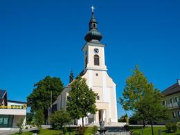
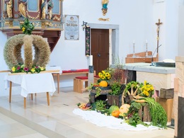


In the birthplace of dialect poet Norbert Hanrieder, the tried and tested is just as enduring as the beauty of the landscape with its striped meadows and legendary rock formations. It lies on the Bavarian border, just 40 kilometres from Passau. The parish church of St. Joseph is well worth a visit. The church was built from 1787-1800 in the late Baroque style. There is a nice story surrounding the valuable high altar with the altarpiece "Death of St Joseph" from 1746: it originally stood as a side altar in the Schlägl collegiate church and was to be moved to Kollerschlag by order of the authorities. When the priests refused, the villagers moved it to Schlägl with ladder wagons and dismantled it themselves. Kollerschlag made amends for this "altar theft" on the occasion of the 1992 provincial exhibition by handing over a man-sized replica created by local sculptors to the monastery.
Beautiful natural monuments include the mighty cemetery lime trees and several legendary rock formations. The Hochstein (860 m) is also popularly known as the "Burgstall". During excavations, evidence was found that there may indeed have been a clearing of the Falkensteins here. The restored wolf pit is located nearby. According to tradition, wolves were lured into the trap here. The printer Franzl Stein is said to be where the robber Franz Niedl, who was executed in Passau in 1754, hid. Catholic clergymen found refuge from the Bohemian Hussites, who invaded the Mühlviertel in the 15th century, in the Pfaffenhaus rock cave. According to legend, the devil frightened the clergy from the devil's seat, also known as "the stone with the three faces". The hamlet below was therefore called "Schröck". The popular "Stoanaweg" hiking trail leads along these stones and further along the Kühstein, Bründlstein, Hüllstein and Lochstein.
Norbert Hanrieder:
Perhaps an "almost forgotten landscape", but certainly not a landscape to forget! The "Leitn", "Hübln", "Gstettn" and "Stoa" characterise the face of the landscape - at least where they were and are superior to tractors, ploughs and bulldozers.
1.490Inhabitants
17.43 km²Area
726 m ASLElevation
48.60, 13.84GPS coordinates
From Linz via the B127 towards Rohrbach. Continue towards Oepping or Kollerschlag on the B38 federal road.
From Passau via Erlau, Obernzell and Wegscheid to Kollerschlag.
The nearest railway stations are Oepping (13.5km) and Rohrbach-Berg (16km).
Linz/Hörsching airport.
")
")

")
Contact
Markt 14
4154 Kollerschlag
Phone +43 7287 8155
Fax machine +43 7287 8155 - 15
E-Mail info@boehmerwald.at
Web www.boehmerwald.at/
https://www.boehmerwald.at/
You can also visit us on
Visit us on Facebook Visit us on Instagram Visit our videochannel on YouTube powered by TOURDATA
