Rohrbach-Berg
Rohrbach-Berg, Oberösterreich, Österreich
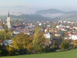


Today, Rohrbach-Berg is known as a shopping, sports and school town. The district town lives up to its reputation as a dynamic shopping and recreational town thanks to its wide range of sectors. For your active summer holiday, you will find numerous marked hiking, cycling and running routes.
For the swimming season, the new AquaRo adventure pool with diving tower, giant slide and lazy river is just the thing.
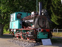
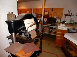
Our Museums provide information about the history of letterpress printing and the development of the Mühlkreisbahn railway. In the Museum of the Senses "Villa Sinnenreich" you can experience all kinds of sensory illusions!The Wallfahrtskirche Maria Trost is very popular with pilgrims from near and far. From the southern edge of the Berger forest, a "Hainsimsen beech forest" (a phytosociological treasure), walkers, joggers and Nordic walkers can enjoy a fantastic view, even as far as the Alps on fine days.
In terms of landscape, Rohrbach-Berg is part of the Zwischenmühl ridge, which slopes down from north to south.
History:
A trade route already led through Berg around the year 1000. Berg (then Perg) is first mentioned in documents in 1231, when "Henricus de Monte" appears as a witness to a document. The Perger or "de monte" had built their ancestral castle at the top of the mountain. The Perger family was followed by the Rödern family. Hans von Rödern built a new castle halfway up the mountain and let the ancestral castle fall into disrepair. The castle was burnt down in 1626 in the course of the peasants' crises. Following the extinction of the Rödern family (1744), disputes arose over the estate. At the beginning of the 20th century, the estate was divided up. The Meierhof (Grimshof) belonging to the castle came into bourgeois hands around 1820. The tower and parts of the outer wall with a Renaissance portal still remain from the castle.
The region originally belonged to Passau Abbey. In 1319, Passau ceded the parish rights to Schlägl Abbey. Early Rohrbach was a thoroughfare for traders and warriors. Due to its favourable traffic location at the intersection of the "Goldener Steig" salt trade route and the "via regia", a settlement was already established around the year 1000. The "via regia" was the much-travelled royal road from Linz to Bohemia. Around 1200, the market was laid out by 44 original citizens (the first market charter in 1320 was lost in the turmoil of the Hussite Wars, in 1459 the market rights were renewed by Duke Albrecht). The trade in salt (until 1750), cattle, hops, linen and leather caused Rohrbach to flourish rapidly. The world wars and their effects brought a setback to Rohrbach, as elsewhere. The many schools, offices and the hospital made Rohrbach the centre of the Upper Mühlviertel and promoted its development into a dynamic shopping town. So it is no wonder that today's Rohrbach-Berg was elevated to town status in 1986.
For the swimming season, the new AquaRo adventure pool with diving tower, giant slide and lazy river is just the thing.
Our Museums provide information about the history of letterpress printing and the development of the Mühlkreisbahn railway. In the Museum of the Senses "Villa Sinnenreich" you can experience all kinds of sensory illusions!The Wallfahrtskirche Maria Trost is very popular with pilgrims from near and far. From the southern edge of the Berger forest, a "Hainsimsen beech forest" (a phytosociological treasure), walkers, joggers and Nordic walkers can enjoy a fantastic view, even as far as the Alps on fine days.
In terms of landscape, Rohrbach-Berg is part of the Zwischenmühl ridge, which slopes down from north to south.
History:
A trade route already led through Berg around the year 1000. Berg (then Perg) is first mentioned in documents in 1231, when "Henricus de Monte" appears as a witness to a document. The Perger or "de monte" had built their ancestral castle at the top of the mountain. The Perger family was followed by the Rödern family. Hans von Rödern built a new castle halfway up the mountain and let the ancestral castle fall into disrepair. The castle was burnt down in 1626 in the course of the peasants' crises. Following the extinction of the Rödern family (1744), disputes arose over the estate. At the beginning of the 20th century, the estate was divided up. The Meierhof (Grimshof) belonging to the castle came into bourgeois hands around 1820. The tower and parts of the outer wall with a Renaissance portal still remain from the castle.
The region originally belonged to Passau Abbey. In 1319, Passau ceded the parish rights to Schlägl Abbey. Early Rohrbach was a thoroughfare for traders and warriors. Due to its favourable traffic location at the intersection of the "Goldener Steig" salt trade route and the "via regia", a settlement was already established around the year 1000. The "via regia" was the much-travelled royal road from Linz to Bohemia. Around 1200, the market was laid out by 44 original citizens (the first market charter in 1320 was lost in the turmoil of the Hussite Wars, in 1459 the market rights were renewed by Duke Albrecht). The trade in salt (until 1750), cattle, hops, linen and leather caused Rohrbach to flourish rapidly. The world wars and their effects brought a setback to Rohrbach, as elsewhere. The many schools, offices and the hospital made Rohrbach the centre of the Upper Mühlviertel and promoted its development into a dynamic shopping town. So it is no wonder that today's Rohrbach-Berg was elevated to town status in 1986.
5.150Inhabitants
37.9 km²Area
479 - 749 m ASLElevation
48.57, 13.99GPS coordinates
Westautobahn - Linz - B 127
About Munich - Landshut - A92 - Deggendorf - Passau A3 - Exit
North via Wegscheid
About Nuremberg - Regensburg A3 - Passau - Exit North via Wegscheid
Top highlights
")
")
")
")
")
")
")
")
")
")
Contact
Stadtplatz 1
4150 Rohrbach-Berg
Phone +43 5 7890 - 310
Fax machine +43 5 7890 - 315
E-Mail info@boehmerwald.at
Web www.boehmerwald.at
https://www.boehmerwald.at
You can also visit us on
Visit us on Facebook Visit us on Instagram Visit our videochannel on YouTube powered by TOURDATA
