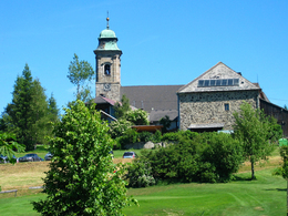
Way of St. James Stage 6 Pfarrkirchen (AT) - Untergriesbach (DE)


- culturally interesting
- Multi-day tour
- Possible accommodation
Interactive elevation profile
Create PDF
Tour-Details
Starting place: 4141 Pfarrkirchen im Mühlkreis
Destination: 94107 Untergriesbach
duration: 5h 30m
length: 19,0 km
Altitude difference (uphill): 306m
Altitude difference (downhill): 553m
Lowest point: 493m
Highest point: 820m
difficulty: medium
condition: medium
panoramic view: Great panorama
Paths covering:
Asphalt, Hiking trail
powered by TOURDATA
Section of the St. James's Path from Pfarrkirchen to Untergriesbach.
From the centre of Pfarrkirchen, pass the cemetery and turn left behind the church onto the
"Lugbauernweg". The route first descends on a meadow path and then continues on a forest path to the village of Wehrbach. Through the village of Wehrbach - chapel in the centre of the village - then left to the single farmstead "Lugbauer". Continue on a meadow path and then through the forest to Altenhof, to the centre of the village and the GH Mayrhofer, continue on the main road and to the right of Altenhof Castle into the valley to the Stockschützenhalle.
There you turn left onto a goods road, after approx. 500 m you come to the "Hofmühle". From there, the route leads into the Rannatal valley, through the forest along the water pipeline to the Rannastausee reservoir (dam wall), along the fitness trail to the Konzinger footbridge, cross it and continue into the municipality of Neustift. Immediately after the Konzinger Steg, turn right and follow the Seenweg for a short distance.
After approx. 50 metres, a path leads uphill on the left-hand side. Follow this path to the edge of the forest. There begins an asphalted goods road which after approx. 1.5 km leads into the Rannataler Landesstraße, here we turn right and come directly into the centre of Neustift.
A variation option in Neustift would be to turn off via the Falkensteinerweg
110 onto the Donausteig. On the Danube ridge it is still about 30 km to Passau.
Neustift to Gottsdorf: Without turning off, we follow the road past the church and the
municipal office towards the German border. About 100 metres before the border crossing
we leave the main road again and turn left onto the Haitzendorf estate road. Again
after approx. 100 metres, at the municipal gritting silo, we turn right into the forest and
follow the forest path (Schmugglersteig). After approx. 1 km, this path leads us to the 47
border stone and we have thus arrived directly at the German border.
Gottsdorf to Untergriesbach: Follow the field path to the road, continue towards Gottsdorf, after the
church head west, turn right at the outdoor pool and immediately left again up the hill to
Ramesberg. There, after Löschweiler, turn left to Stollberg, continue to Kronawitthof, Diendorf,
Richtermühle and finally to Untergriesbach.
Stamping point for Way of St James stamp: Gasthaus Wundsam, Passauer Straße 1, 4143 Neustift
Further stages on this Way of St. James route.
Request our maps for EUR 3.00!
With the free app outdooractive you can hike the route by navigation.
Starting point: The starting point for this stage is Pfarrkirchen.
Destination: The destination is Untergriesbach in Germany.
further information:
- Multi-day tour
- Possible accommodation
- Board possible
Details - hiking
- themed path
Most economical season
- Spring
- Summer
- Autumn
Please get in touch for more information.
Hauptstraße 2
4160 Aigen-Schlägl
Phone +43 5 7890 - 100
Fax machine +43 5 7890 - 115
E-Mail info@boehmerwald.at
Web www.boehmerwald.at/
https://www.boehmerwald.at/
You can also visit us on
Visit us on Facebook Visit us on Twitter Visit us on Instagram Visit our videochannel on YouTubeInteractive elevation profile
Create PDF
Tour-Details
Starting place: 4141 Pfarrkirchen im Mühlkreis
Destination: 94107 Untergriesbach
duration: 5h 30m
length: 19,0 km
Altitude difference (uphill): 306m
Altitude difference (downhill): 553m
Lowest point: 493m
Highest point: 820m
difficulty: medium
condition: medium
panoramic view: Great panorama
Paths covering:
Asphalt, Hiking trail
powered by TOURDATA
