Herbal dough


- Flatly
- Possible accommodation
Interactive elevation profile
Create PDF
Tour-Details
Path number: 23
Starting place: 4163 Klaffer am Hochficht
Destination: 4163 Klaffer am Hochficht
duration: 2h 0m
length: 6,8 km
Altitude difference (uphill): 67m
Altitude difference (downhill): 67m
Lowest point: 588m
Highest point: 635m
difficulty: easy
condition: easy
panoramic view: Great panorama
Paths covering:
Asphalt, Hiking trail
powered by TOURDATA
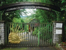
Klaffer am Hochficht is known for its medicinal herb garden. Sports shoes are also suitable for this easy walk.
0 km You walk from the village centre Klaffer (car park at the municipal office) to the parish church. Once there, you will see the herb garden on the right. On an area of 7,800 m2, approx. 1000 different medicinal plants grow and thrive, which are laid out in various landscapes. (e.g. alpine garden, cottage garden, biotope, heathland, etc.). The hike leads past the herb garden on the left and down to the ...
1.1 km Große Mühl. After crossing the footbridge, take the path on the left. The path runs parallel to the Torfaurunde for a short distance. You will immediately pass the ...
1.3 km Seitelschläger Mühle (derelict) and keep coming across information boards for the ...
1.4 km Torfau nature reserve. The nature conservation youth of Haslach an der Mühl created the adventure trail together with the agricultural district authority. Topics such as the landscape history of the village of Seitelschlag, crop rotation, fauna and flora habitats and monoculture can be read about on display boards. Turn right off the Torfaurunde and onto a...
3.0 km asphalt road coming from Seitelschlag/Golfpark. Cross the Große Mühl in the valley and immediately afterwards take the path on the right. Follow this path, leaving the access road to the bathing lake on your left and shortly afterwards turn left onto the dirt track. After a few minutes, slightly uphill, you will see the bathing lake on the left, continue and come to the ...
4.4 km junction "in 10 min. to Mühl-fun-viertel". Here you have the option of walking around Lake Urlsee along the fishing and plant nature trail. Or you can continue to the right until you reach the junction with the tarmac road. Immediately afterwards, cross the road and turn left, past the Hauer joinery until just before the Donabauer candle factory. Now continue right, walking a short distance below the village of Klaffer, back to ...
6.8 km Starting point
Request our hiking map for EUR 3.00!
With the free outdooractive app, you can hike the trail using navigation.
Starting point: Local centre, car park at the municipal office.
Destination: Local centre, car park at the municipal office.
further information:
- Flatly
- Possible accommodation
- Board possible
Most economical season
- Spring
- Summer
- Autumn
Please get in touch for more information.
Dorfplatz 1
4163 Klaffer am Hochficht
Phone +43 5 7890 - 100
Fax machine +43 5 7890 - 115
E-Mail info@boehmerwald.at
Web www.boehmerwald.at/
https://www.boehmerwald.at/
You can also visit us on
Visit us on Facebook Visit us on Twitter Visit us on Instagram Visit our videochannel on YouTube")
")
")
")
")
Interactive elevation profile
Create PDF
Tour-Details
Path number: 23
Starting place: 4163 Klaffer am Hochficht
Destination: 4163 Klaffer am Hochficht
duration: 2h 0m
length: 6,8 km
Altitude difference (uphill): 67m
Altitude difference (downhill): 67m
Lowest point: 588m
Highest point: 635m
difficulty: easy
condition: easy
panoramic view: Great panorama
Paths covering:
Asphalt, Hiking trail
powered by TOURDATA
