Holzschlagrunde


- Suitable for pushchairs
- Flatly
Interactive elevation profile
Create PDF
Tour-Details
Path number: 25
Starting place: 4163 Klaffer am Hochficht
Destination: 4163 Klaffer am Hochficht
duration: 2h 0m
length: 7,9 km
Altitude difference (uphill): 228m
Altitude difference (downhill): 228m
Lowest point: 889m
Highest point: 1.083m
difficulty: medium
condition: medium
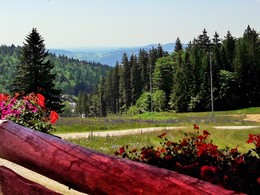
panoramic view: Great panorama
Paths covering:
Asphalt, Gravel
powered by TOURDATA
Pleasant family hike in the Hochficht ski area. This forest hike leads along forest paths and is also accessible with a pram.
0 km You start the hike at the parking area of the Hochficht valley station - ski arena. Keep left at the ticket office. Now a short uphill section of forest road begins, which you follow until you reach the upper car park. Here the Nordwaldkammweg crosses the forest road. The two turn-offs "Ereignishaus Holzschlag" and "Gasthaus zum Überleben" are steep paths and not suitable for pushchairs.
The forest road now becomes flatter and you continue straight ahead. You emerge from the forest and see the Rehberg descent in front of you. Looking left, the Zwieselberg descent. On the right, the forest path (now accessible with pushchairs) leads you to ...
2.2 km Gasthaus zum Überleben on the so-called Wenzelwiese. The house was first mentioned in building law in 1827. It was owned by the Reischl family until 1985 and now belongs to Schlägl Abbey. Back at the forest road, continue to the right. Cross the piste of the Rehberg descent before plunging into the forest ahead of you. Climbing slightly at first and then descending again, you reach ...
3.4 km to the turn-off to the border crossing 1/10 (only open to pedestrians and cyclists).
Here you will come across the signs for Plöckensteinerseeweg trail no. 21. Turn left and continue downhill on the forest path. You cross the lift and downhill road of the Rehberglift again and reach ...
6.6 km Ereignishaus Holzschlag. Follow the access road to the crossroads, where you turn left and walk uphill to the ...
7.9 km starting point.
Request our hiking map for EUR 3.00!
With the free app outdooractive you can hike the trail by navigation.
Starting point: Car park Skiarena Hochficht.
Destination: Car park Skiarena Hochficht.
further information:
- Flatly
- Board possible
- Suitable for pushchairs
- Spring
- Summer
- Autumn
Please get in touch for more information.
Dorfplatz 1
4163 Klaffer am Hochficht
Phone +43 5 7890 - 100
Fax machine +43 5 7890 - 115
E-Mail info@boehmerwald.at
Web www.boehmerwald.at/
https://www.boehmerwald.at/
You can also visit us on
Visit us on Facebook Visit us on Twitter Visit us on Instagram Visit our videochannel on YouTube")
")
")
Interactive elevation profile
Create PDF
Tour-Details
Path number: 25
Starting place: 4163 Klaffer am Hochficht
Destination: 4163 Klaffer am Hochficht
duration: 2h 0m
length: 7,9 km
Altitude difference (uphill): 228m
Altitude difference (downhill): 228m
Lowest point: 889m
Highest point: 1.083m
difficulty: medium
condition: medium
panoramic view: Great panorama
Paths covering:
Asphalt, Gravel
powered by TOURDATA
