Weiselweg


- Flatly
- Possible accommodation
Interactive elevation profile
Create PDF
Tour-Details
Path number: 8
Starting place: 4162 Julbach
Destination: 4162 Julbach
duration: 2h 30m
length: 8,0 km
Altitude difference (uphill): 301m
Altitude difference (downhill): 301m
Lowest point: 517m
Highest point: 785m
difficulty: medium
condition: medium
panoramic view: Great panorama
Paths covering:
Asphalt, Hiking trail
powered by TOURDATA
Recharge your batteries on the Weiselweg hiking trail.
On the hiking trail, you will come across 6 stations that focus on the topic of health. The highlight is the Hüttner adventure apiary with its focus on "Breathe healthy with bee air".
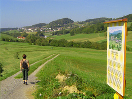
0 km You start the hike at the Pernsteiner room rental in Niederkraml and hike a short distance on the tarmac road towards Julbach, parallel to the Guckerweg trail no. 7. 7. At the "Julbachblick" peeper station and the ...
0.5 km information board "Gemeinde Julbach", which is also dedicated to the topic of "climate", turn into the meadow path and cross the "Kleine Mühl" river in the valley. Here you will find another information board on the topic of water, where there is a nice rest area. Now you walk uphill towards the village of Julbach (you can also start in Julbach).
2.3 km In the Unterort district, continue along the Schlägerbergweg trail. The hike now takes you uphill through the residential area towards the forest. At the edge of the forest, you can read interesting facts about the "forest" on the ...
2.9 km information board. At the bench, it is worth taking a look back at Julbach (also known as the "Merano of the Mühlviertel" due to its mild climate). The forest path that follows continues to climb until you reach a beautiful spot, the mountain meadow. Enjoy the peace and quiet on the bench and recharge your batteries.
4.0 km On the theme board you will learn interesting facts about plants and herbs. The forest path climbs again briefly to the highest point of the hike. Walking downhill, you reach the ...
4.6 km "Agriculture" station at the edge of the forest and immediately pass a beautiful farmstead. A little-used section of road leads you down into the Kleine Mühl valley. Before that, you will pass ...
5.6 km Erlebnisimkerei Hüttner. The turn-off is easy to miss. So look out for the turn-off on the right-hand side of the road.
The bees bring nectar, pollen and resins and many other natural substances to the beehive. Here they are processed by around 60,000 bees, creating vapours with soothing aromas. These vapours are balm for the respiratory organs and for the soul. See for yourself with a bee air treatment at the Hüttner beekeeping experience.
On reaching the valley, turn left onto the road coming from Julbach. Shortly afterwards, turn into the Höhlschmiede goods road. At the Egermühle mill, cross the Kleine Mühl river and continue along the forest path. Climb slightly uphill through the forest and continue along the meadow path, where you end the themed hike at the ...
8 km starting point Niederkraml .
To rule a bee colony, you need a leader. Our ancestors thought in terms of men. For them, the leader of a bee colony was naturally a man, and a wise and intelligent one at that. So he was given the name "wise man". But because he was small, he was called "Weisel". The cradle of the future queens is still called the "Weiselnapf" today out of old custom.
Request our hiking map for EUR 3.00
With the free outdooractive app, you can hike the trail using navigation.
On the hiking trail, you will come across 6 stations that focus on the topic of health. The highlight is the Hüttner adventure apiary with its focus on "Breathe healthy with bee air".
0 km You start the hike at the Pernsteiner room rental in Niederkraml and hike a short distance on the tarmac road towards Julbach, parallel to the Guckerweg trail no. 7. 7. At the "Julbachblick" peeper station and the ...
0.5 km information board "Gemeinde Julbach", which is also dedicated to the topic of "climate", turn into the meadow path and cross the "Kleine Mühl" river in the valley. Here you will find another information board on the topic of water, where there is a nice rest area. Now you walk uphill towards the village of Julbach (you can also start in Julbach).
2.3 km In the Unterort district, continue along the Schlägerbergweg trail. The hike now takes you uphill through the residential area towards the forest. At the edge of the forest, you can read interesting facts about the "forest" on the ...
2.9 km information board. At the bench, it is worth taking a look back at Julbach (also known as the "Merano of the Mühlviertel" due to its mild climate). The forest path that follows continues to climb until you reach a beautiful spot, the mountain meadow. Enjoy the peace and quiet on the bench and recharge your batteries.
4.0 km On the theme board you will learn interesting facts about plants and herbs. The forest path climbs again briefly to the highest point of the hike. Walking downhill, you reach the ...
4.6 km "Agriculture" station at the edge of the forest and immediately pass a beautiful farmstead. A little-used section of road leads you down into the Kleine Mühl valley. Before that, you will pass ...
5.6 km Erlebnisimkerei Hüttner. The turn-off is easy to miss. So look out for the turn-off on the right-hand side of the road.
The bees bring nectar, pollen and resins and many other natural substances to the beehive. Here they are processed by around 60,000 bees, creating vapours with soothing aromas. These vapours are balm for the respiratory organs and for the soul. See for yourself with a bee air treatment at the Hüttner beekeeping experience.
On reaching the valley, turn left onto the road coming from Julbach. Shortly afterwards, turn into the Höhlschmiede goods road. At the Egermühle mill, cross the Kleine Mühl river and continue along the forest path. Climb slightly uphill through the forest and continue along the meadow path, where you end the themed hike at the ...
8 km starting point Niederkraml .
To rule a bee colony, you need a leader. Our ancestors thought in terms of men. For them, the leader of a bee colony was naturally a man, and a wise and intelligent one at that. So he was given the name "wise man". But because he was small, he was called "Weisel". The cradle of the future queens is still called the "Weiselnapf" today out of old custom.
Request our hiking map for EUR 3.00
With the free outdooractive app, you can hike the trail using navigation.
Starting point: Room rental Pernsteiner, Niederkraml bei Julbach.
Destination: Room rental Pernsteiner, Niederkraml bei Julbach.
further information:
- Flatly
- Possible accommodation
- Board possible
Details - hiking
- themed path
Most economical season
- Spring
- Summer
- Autumn
Please get in touch for more information.
Schulstraße 4
4162 Julbach
Phone +43 5 7890 - 100
Fax machine +43 5 7890 - 115
E-Mail info@boehmerwald.at
Web www.boehmerwald.at/
https://www.boehmerwald.at/
You can also visit us on
Visit us on Facebook Visit us on Instagram Visit our videochannel on YouTube")
")

")
Interactive elevation profile
Create PDF
Tour-Details
Path number: 8
Starting place: 4162 Julbach
Destination: 4162 Julbach
duration: 2h 30m
length: 8,0 km
Altitude difference (uphill): 301m
Altitude difference (downhill): 301m
Lowest point: 517m
Highest point: 785m
difficulty: medium
condition: medium
panoramic view: Great panorama
Paths covering:
Asphalt, Hiking trail
powered by TOURDATA
