On the way to deceleration: Recharge your energy to 165 km in 9 days


- Multi-day tour
- Flatly
- Possible accommodation
Interactive elevation profile
Create PDF
Tour-Details
Paths covering:
Hardly anything has become rarer and more valuable in our overheated meritocracy than time and leisure. The hectic pace of life, the vast amount of digital communication and the need to be available everywhere and at all times intensify the desire to leave everything behind and switch off. Over two thousand years ago, philosophers such as Socrates, Plato and Epicurus taught that people need "otium" - divine leisure - to be in harmony with themselves.
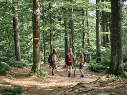
Enjoy the peace and quiet on the path of deceleration. Beautiful benches invite you to linger at the numerous ancient power spots and viewpoints. Where it wasn't possible to set up benches, you can use your deckchair and sit in the shade of the large old trees or on the ancient granite blocks of the Bohemian Forest. Pause for a moment and feel the invigorating energy - you will leave the Bohemian Forest feeling well rested.
All stages have one thing in common: as soon as you leave the villages, the tranquillity of nature surrounds you. Hike through the varied landscape and discover something new every day. From the valleys of the Große, Kleine and Steinerne Mühl to the ridge of the Bohemian Forest, nature offers plenty of variety.
- Stage 1: Aigen-Schlägl - Haslach 19 km
- Stage 2: Haslach - Helfenberg 20 km
- Stage 3: Helfenberg - Rohrberg 20 km
- . Stage: Helfenberg - Rohrbach-Berg 20 km
- 4. Stage: Rohrbach-Berg - Peilstein 16 km
- 5. Stage: Peilstein - Kohlstatt 19 km
- 6. Stage: Kohlstatt - Schwarzenberg 20 km
- 7. Stage: Schwarzenberg - Holzschlag 21 km
- 8th stage: Holzschlag - Hintenberg 16 km
- 9th stage: Hintenberg - Aigen-Schlägl, 14 km
On request, we will also be happy to provide you with a detailed description of the stage. This is also available for download under Multimedia/Documents.With the free outdooractive app, you can hike the route using navigation.
further information:
- Multi-day tour
- Flatly
- Possible accommodation
- Experience of nature
- Board possible
Details - hiking
- themed path
1 May until 31 October
Travelling to Aigen
West Motorway - Linz - B 127
Via Munich - Landshut - A92 - Deggendorf - Passau A3 - Exit
Nord via Wegscheid
Via Nuremberg - Regensburg A3 - Passau - Exit Nord via Wegscheid
9 nights per person:
from EUR 553.00 incl. breakfast
Luggage transfer and packed lunch included.
- Suitable for single travelers
- Suitable for couples
- Spring
- Summer
- Autumn
Please get in touch for more information.
Hauptstraße 2
4160 Aigen-Schlägl
Phone +43 5 7890 - 100
Fax machine +43 5 7890 - 115
E-Mail info@boehmerwald.at
Web www.wegderentschleunigung.at
You can also visit us on
Visit us on Facebook Visit us on Instagram Visit our videochannel on YouTube")
")
")
")
Interactive elevation profile
Create PDF
Tour-Details
Paths covering:
